Construction Drone Video & Aerial Photography
615-812-6102
Nashville Drone Co works with general contractors, builders, developers, and construction management teams throughout Middle Tennessee to create aerial photography, drone video, and site documentation that serves both operational and marketing purposes. Every project is handled by our in-house team of FAA-certified pilots, not subcontracted, so you get consistent quality and direct communication from the first site visit through final delivery.
Construction sites present unique planning and safety challenges that require experienced pilots who know how to work around active crews, equipment, and evolving site conditions. Nashville Drone Co has documented construction projects ranging from luxury custom homes and residential subdivisions to major commercial developments and high-rise builds throughout Nashville and Middle Tennessee. We understand what project managers, developers, and marketing teams need from aerial content and we deliver it on schedule.
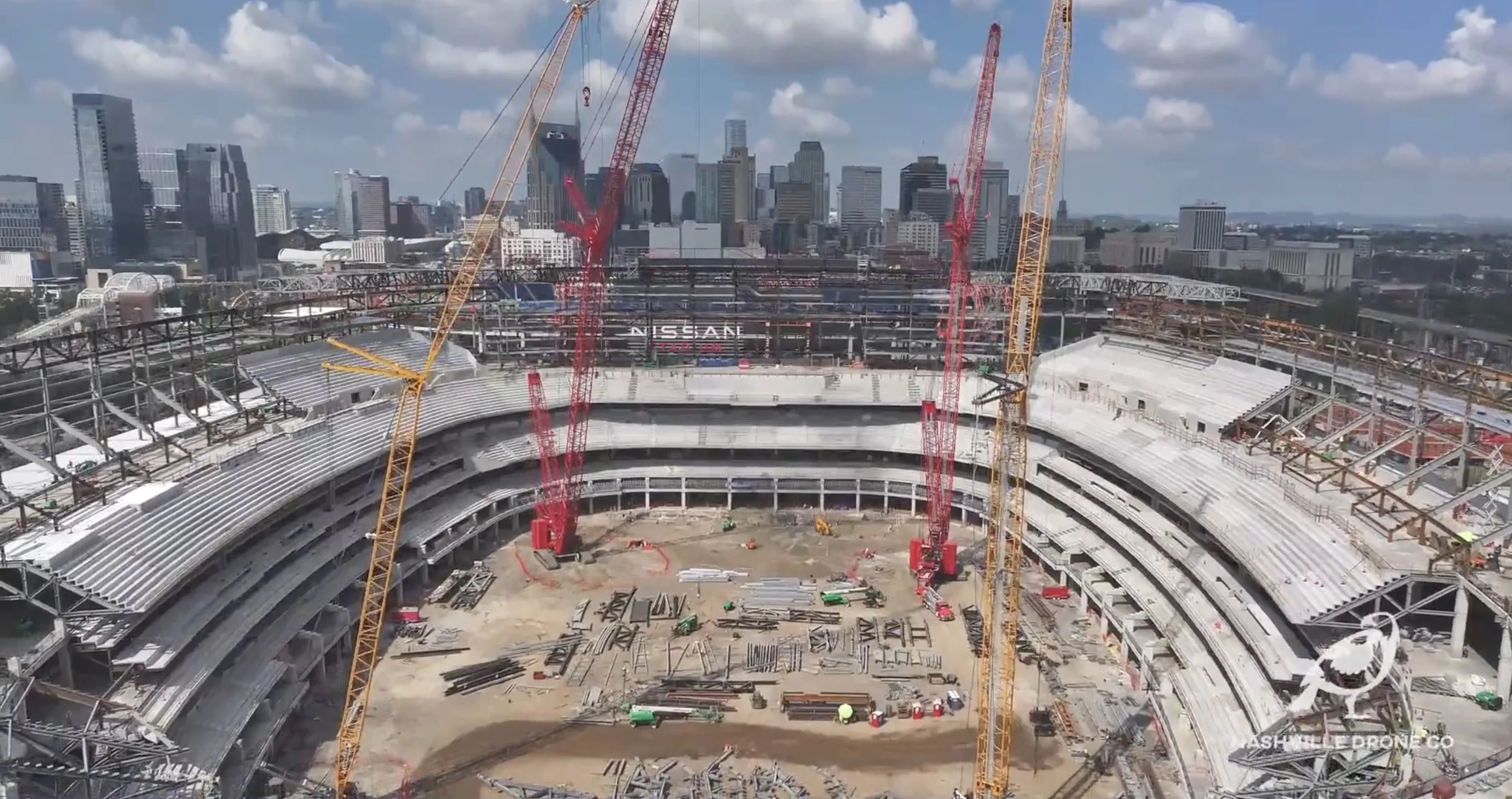
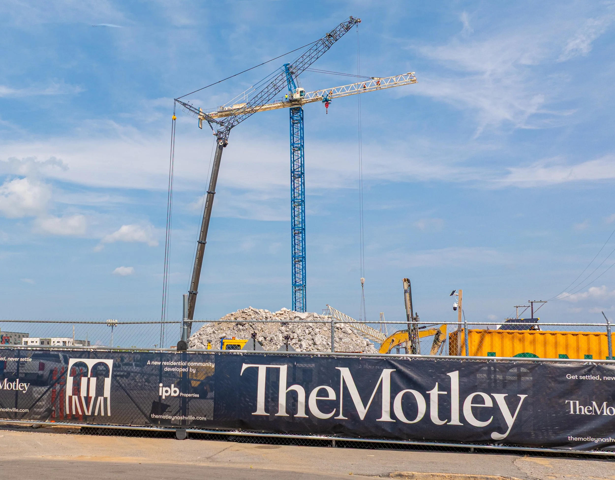
Nashville Drone Co has produced construction drone video for some of the most recognized projects and companies in Middle Tennessee including The Motley Nashville high-rise development with Axiom Builders and IPB Properties, Giarratana Development's Paramount Nashville, McCrory Construction's Walmart development in Lebanon, and multiple commercial and residential concrete companies throughout Middle Tennessee.
Our Construction Drone Services
-
Construction Progress
Track, Document, and Showcase Every Phase of Your Construction Project with Aerial Precision
Our Construction Progress Drone Services provide high-resolution aerial photography and 4K video footage tailored for construction sites of all sizes. Using state-of-the-art drones, we capture consistent, time-stamped visuals that help project managers, developers, and stakeholders monitor progress, ensure site safety, and maintain transparency from groundbreaking to completion.
Key Features:
Scheduled Aerial Site Visits (weekly, bi-weekly, or monthly)
High-Resolution Images & 4K Video Footage
Time-Lapse Construction Videos
Progress Reporting for Stakeholders & Investors
Whether you need to track milestones, verify contractor work, or impress investors with visual updates, our drone construction progress services deliver unmatched clarity, consistency, and value.
Ideal For:
Commercial and Residential Construction Sites
Infrastructure Projects
Real Estate Developments
Renovations and Expansions
Get a Custom Quote Today
Make smarter decisions with an aerial view. Contact us now to schedule your first drone flight or to learn how our aerial construction progress solutions can elevate your next project. info@nashvilledrone.co
-
Construction Marketing
Showcase Your Construction Projects with Stunning Aerial Visuals That Sell
Enhance your marketing strategy with our Construction Marketing Drone Services, designed to capture your projects from powerful, attention grabbing aerial perspectives. We help builders, developers, architects, and marketing teams create compelling visuals that highlight craftsmanship, scale, and progress — perfect for websites, social media, investor presentations, and promotional materials.
What’s Included:
High-Resolution Aerial Photography
Cinematic 4K Drone Videography
Branded Promotional Videos
Before-and-After Comparisons
Time-Lapse Construction Videos
Social Media-Optimized Content
Our FAA-certified drone pilots and creative team deliver polished, professional content that tells your story, builds brand credibility, and drives buyer and investor interest.
Perfect for:
Real Estate Developers & Builders
General Contractors & Subcontractors
Architectural Firms
Marketing & PR Agencies in Construction
Why Use Drones for Construction Marketing?
Highlight Project Scope and Quality from Above
Capture Progress and Milestones with Visual Impact
Boost Online Visibility with SEO-Rich Multimedia Content
Engage Your Audience Across All Platforms
From groundbreaking to ribbon-cutting, our drone visuals make your projects stand out in a crowded market.
Get in Touch for a Custom Quote
Ready to market your construction project with visuals that make an impact? Contact us today to schedule a flight or learn more about our drone marketing packages. info@nashvilledrone.co
-
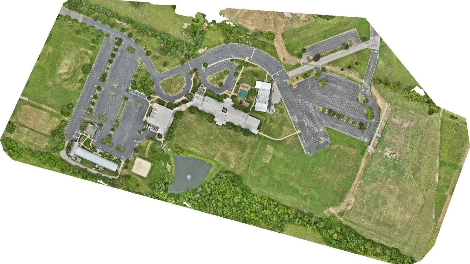
Drone Mapping
High-Resolution Aerial Maps for Smarter Planning and Better Decision Making
Our Drone Mapping Services provide precise aerial data to support industries like construction, agriculture and real estate. Using advanced drone technology and photogrammetry software, we deliver high-resolution 2D orthomosaic maps, 3D models, elevation data, and more.
Our Drone Mapping Capabilities Include:
2D Orthomosaic Maps
3D Site Modeling
Volumetric Measurements
Construction Site Progress Mapping
Ideal For:
Construction
Land Development & Urban Planning
Why Choose Drone Mapping?
Faster Data Collection over large or hard-to-reach areas
Actionable Insights with deliverables tailored to your workflow
Whether you're mapping terrain, measuring volumes, or planning infrastructure, our drone mapping solutions deliver the data you need — when and where you need it.
Request a Free Consultation
Get aerial mapping solutions for your next project. Contact us today to schedule a flight. info@nashvilledrone.co
Recent Construction Video McCrory Construction Walmart site
We recently filmed a drone video project for McCrory Construction, highlighting the impressive scope and progress of a new Walmart build. Using smooth cinematic aerial footage, we captured key construction activities, site logistics, and the overall transformation of the property. The video serves as both a valuable project documentation tool and a powerful marketing asset that demonstrates the expertise and quality behind the build.
Recent Construction Drone for Axiom Builders & IPB Properties
Nashville Drone Co produced construction progress documentation and marketing drone video for The Motley, a high-rise residential development currently under construction in Nashville, Tennessee. Built by Axiom Builders and developed by IPB Properties, The Motley is one of the most anticipated residential projects in the city and Nashville Drone Co was on-site to document it from above.
Recent Construction Drone Video for Giarratana Development Paramount
Nashville Drone Co produced this marketing video for Giarratana Development's Paramount Nashville, capturing the active construction site including cranes, rising concrete, and the full scale of the build against the Nashville skyline. The video was created to generate buyer excitement giving prospective buyers a compelling look at the momentum and ambition behind one of Nashville's most anticipated luxury residential developments.
Recent Construction Drone Video for Jeff Jones Concrete
Nashville Drone Co was recently on-site in Columbia, Tennessee to document a residential foundation pour for Jeff Jones Concrete. The project involved a large and technically complex foundation requiring a more intricate pour than a standard residential job.
For concrete contractors like Jeff Jones Concrete, aerial documentation serves two purposes at once. It gives the project team a detailed visual record of the pour, and it creates a marketing asset that communicates capability and craftsmanship to future clients. When a prospective customer is comparing concrete contractors and one company can show aerial footage of a complex large-scale foundation pour handled with precision, that company stands out.
What Construction Clients Say About Our Drone Services
“Nashville Drone Co delivered exceptional drone video and aerial photography for our Paramount project. Nashville Drone Co owner, Keith Stancil, expertly captured stunning future condo views that are instrumental in our pre-sales and marketing efforts. His responsiveness, fast turnaround and creative approach to video marketing made the process seamless. We highly recommend Nashville Drone Co for top-tier aerial visuals” - Tony Giarratana, GIARRATANA, LLC
“Nashville Drone Co did an incredible job. The visibility captured in the drone footage of the construction site allowed me and my team to have an incredible insight to the weekly progress made as well as help us track and ensure that safety protocol was constantly being adhered to and quality of erosion control was being up kept throughout the project. The quick turnaround time also came in handy as were using this footage for multiple reasons on a weekly basis. Highly recommend” - Ben Melton, McCrory Construction
“Recently had the opportunity to collaborate with Keith/Nashville Drone Co on some drone content in Nashville, and it was a fantastic experience. From project alignment, scheduling, responsiveness, through to creative direction/feedback, Keith's professionalism and quality of work was appreciated.” - Willow Mair, Axiom Builders/ The Motley Nashville
“Nashville Drone Co was able to get the drone footage and photos (which turned out fantastic!) that I needed in a very quick timeframe. They were very quick to respond to my inquiry and responsive throughout” - Mike Plotner, CNC Foundations
“Hard to find vendors that check every box. Nashville Drone Co company did so with their price, workmanship, & customer service.” - Zach Helm, Pavement Technology Inc
Construction Drone Service Areas
Nashville Drone Co provides construction drone video, aerial photography, and drone mapping for builders, developers, and general contractors throughout Middle Tennessee. We regularly serve active construction sites in Nashville, Brentwood, Franklin, College Grove, Spring Hill, Nolensville, Columbia, Murfreesboro, Smyrna, Mt Juliet, and Lebanon. We also travel for larger projects outside the immediate Middle Tennessee region.
If you have an active construction project anywhere in Middle Tennessee, contact us to discuss scheduling, recurring site visit packages, and custom pricing for your project scope.
Contact Us | info@nashvilledrone.co | 615-812-6102
FAQ
What types of construction projects do you work on?
We work on all types including residential subdivisions, luxury custom homes, commercial developments, mixed-use projects, infrastructure builds, and land development. If it's being built in Middle Tennessee, we can document it from the air.
How often can you fly on an active construction site?
As often as you need. We offer weekly, bi-weekly, and monthly scheduled site visits, as well as one-time shoots for specific milestones like groundbreakings, topping out ceremonies, and ribbon cuttings. Recurring packages are available for projects that need consistent documentation throughout the build.
Is it safe to fly a drone over an active construction site?
Yes. We plan every site visit carefully. Before each flight we review the site layout, identify any hazards, and coordinate with your site supervisor to make sure the flight doesn't interfere with active work. All of our pilots hold FAA Part 107 certification and carry full liability insurance.
Do you need to notify anyone before flying over a construction site?
We handle all airspace authorizations required for your location. For sites near airports or in controlled airspace, which applies to many locations in the Nashville metro, we secure the necessary FAA authorizations before every flight. You don't need to manage that on your end.
What deliverables will we receive?
Depending on the scope of your project, deliverables can include high-resolution aerial photos, edited 4K drone video, time-lapse sequences, 2D orthomosaic maps, 360° Panoramic Photos. We'll confirm exactly what's included when we put your package together.
How quickly do we receive the footage after a site visit?
Standard delivery is within 5 business days of the shoot. Rush delivery is available if you have a stakeholder presentation, investor meeting, or marketing deadline coming up.
Can you produce marketing content from the same shoot as our progress documentation?
Yes and this is one of the most cost-effective ways to use our services. We can capture progress documentation and marketing-quality footage in the same visit, giving your project team the site data they need while also building a library of content for your website, social media, and investor materials.
Do you work with general contractors, developers, or both?
Both. We work directly with GCs, project owners, real estate developers, architectural firms, and marketing agencies. We're flexible on who we coordinate with on-site and who receives the deliverables.
What areas of Middle Tennessee do you serve?
We regularly serve Nashville, Brentwood, Franklin, Spring Hill, Nolensville, Columbia, College Grove, Murfreesboro, Mount Juliet, Smyrna, Lebanon, and surrounding communities. We also travel for larger projects outside Middle Tennessee.
How do we get started?
Contact us here or email info@nashvilledrone.co with your project address, a brief description of what you need, and your timeline. We'll get back to you quickly with availability and a custom quote.