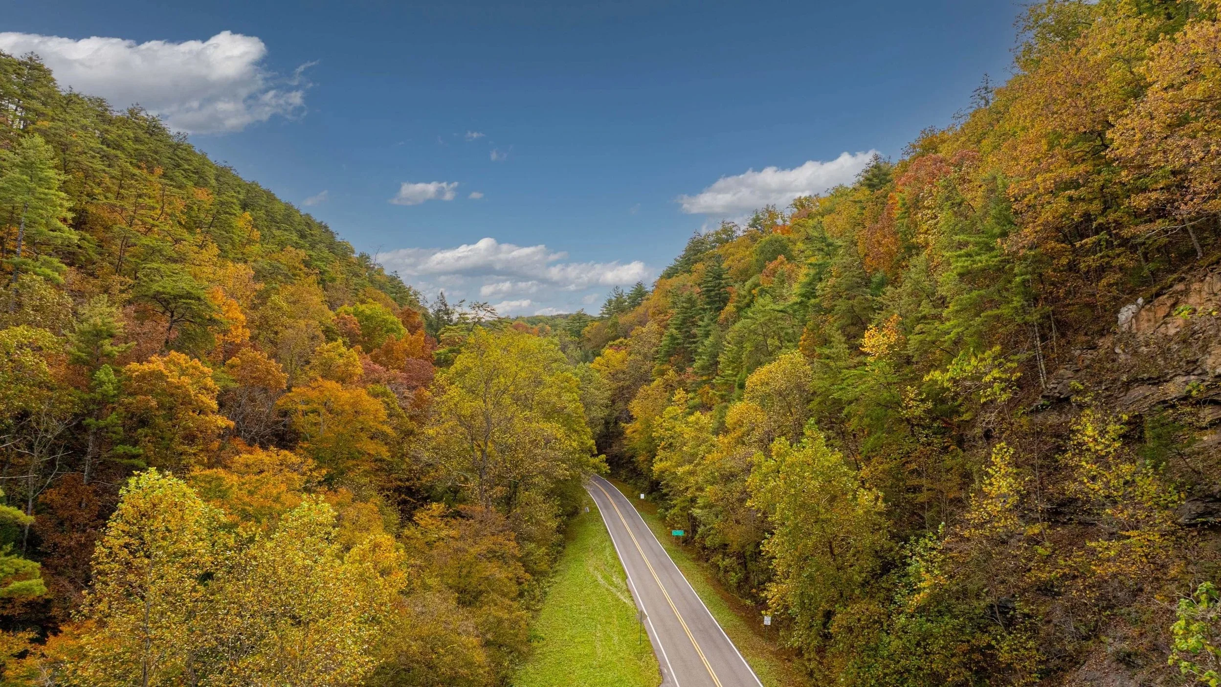
Nashville Drone Co Photo of Entrance to the Tail of the Dragon in East Tennessee
Tennessee does autumn differently than almost anywhere else. The color arrives in waves, starting on the Cumberland Plateau and the high ridges in October, then rolling down through the river valleys and into the Middle Tennessee hills by early November. For a drone pilot, those weeks are a gift. Roads turn into ribbons of gold, lakes become mirrors, and historic town squares glow under low sun.
At Nashville Drone Co, we have spent years chasing that light across the state. Our founder, Keith Stancil, brings over two decades of professional entertainment marketing experience to every shoot and holds FAA Part 107 certification. This guide covers the places we love for fall aerial photography, the rules to know before you fly, and the composition, lighting and exposure habits that turn a quick snapshot into an image people stop scrolling to admire.
Tail of the Dragon, Where Fall Meets the Open Road
Few roads in America carry a reputation like US 129 along the Tennessee and North Carolina line. The Tail of the Dragon packs 318 curves into 11 miles, and in autumn the Appalachian forest that surrounds it turns the entire corridor into a tunnel of orange, red and amber.
Nashville Drone Co captured the beautiful entrance from the Tennessee side, and it remains one of the images we are proudest of. A digital print of the above image can be purchased HERE. The approach to a location like this decides everything. The entrance is where the road begins to tighten, so the sign, the pavement and the first sweeping bends all have to read clearly in one frame. We planned the flight around the angle of the sun so the ridgeline cast soft shade across the road while the foliage on the far slope stayed lit. That contrast gives the photograph depth. Flat midday light would have washed out the color and hidden the shape of the asphalt.
Altitude shaped the composition too. Fly too low and the curves collapse into a tangle. Fly too high and the road shrinks to a thin line lost in the trees. We looked for a middle height where the road acts as a leading line, pulling the eye from the bottom of the frame up into the hills.
A few practical points matter here. The area sits close to Great Smoky Mountains National Park, where drones are prohibited, so confirm your launch and flight areas before you go. This is also a famous route for motorcyclists and sports cars, so keep your aircraft away from traffic and people, and do not fly over moving vehicles without the proper FAA authorization. Weekday mornings are calmer and safer for everyone.
Monteagle and the Cumberland Plateau
Monteagle sits high on the Cumberland Plateau, and that elevation means color shows up earlier than it does in the valleys below. Hardwood forests spill over the plateau edge, and on clear mornings fog fills the coves while the ridgetops catch the first light. That layered look is what makes Monteagle so photogenic from the air.
Launch before sunrise, angle the camera slightly downward toward the fog and let the warm foliage pop against the pale mist. Parts of the area, including nearby state parks, have their own drone policies, so check with the park or get permission before you take off. Public pull-offs and private land with the owner’s approval are usually your most reliable launch points.
Nickajack Lake
Nickajack Lake stretches along the Tennessee River west of Chattanooga, framed by steep bluffs and forested ridges. In fall, reflections are the star. On calm mornings the water works like a mirror and doubles the color along the shoreline. Fly at a moderate altitude and tilt the camera so the frame holds both the trees and their reflection. Coves, boat ramps and curving shorelines create natural shapes that lead the eye. Keep a respectful distance from dams and other infrastructure, and look for posted restrictions before launching. An ND filter helps cut glare on the water and deepens the foliage color.
Percy Priest Lake
Percy Priest Lake is the place we reach for when we want fall color without a long drive. Especially if you have access to a boat. Minutes from Nashville, the lake offers miles of shoreline, quiet coves and islands managed by the US Army Corps of Engineers.
Golden hour is the time to be there. Low sun lights the hardwoods along the shore while the water holds a deep blue that makes red and orange leaves stand out. Use islands and points of land as foreground layers, and include a kayak or sailboat when you can, since a small human element gives the scene scale. Portions of the lake sit beneath controlled airspace tied to Nashville International Airport, so check LAANC or request authorization before you fly, and follow Corps of Engineers rules around the dam and recreation areas.
Downtown Franklin
Downtown Franklin gives you color on a human scale. Brick storefronts, tree-lined streets and a historic square create a setting that feels made for autumn. One of our favorite images from the area is a straight-down view of the Franklin Square roundabout and the Civil War memorial, flown a couple hundred feet up. From that height the circle, the pavement lines and the surrounding canopy read like a painting rather than a photograph. Top-down photography rewards patience. Wait for a break in traffic, shoot in soft morning light and keep the horizon out of the frame so the geometry carries the image. Avoid flying over crowds during festivals and events unless you hold the proper FAA authorization, and always keep the aircraft within visual line of sight.
Columbia
Columbia, in Maury County, pairs a handsome courthouse square with rolling farmland and the bends of the Duck River. Fall brings red barns, golden pastures and sycamores along the water, all within a short drive of each other.
Start with the square at sunrise for warm light on historic facades, then move to open countryside, where long shadows stretch across the fields. Get permission from landowners before launching on private property, and stay clear of livestock, since the sound of a drone can spook animals.
Chattanooga
Chattanooga is a natural fit for fall aerial work. The Tennessee River winds through the gorge, the Walnut Street Bridge spans the water, and the ridges of Lookout Mountain and Signal Mountain rise behind the city.
Try a sunrise flight along the river to catch mist lifting off the water, or a late afternoon flight that sets the downtown skyline against glowing hillsides. Chattanooga sits near controlled airspace, so authorization through LAANC is often required. Parts of Lookout Mountain are managed by the National Park Service, where drones are not allowed, so plan your launch points with care.
Composition, Lighting and Exposure for Fall Drone Photos
Location gets you in the door, but craft makes the image. These are the habits we rely on for every fall shoot.
Composition
Build the frame in layers. A strong foreground, a middle ground and a distant background give the viewer a path to follow. Use roads, rivers and shorelines as leading lines, and place your subject along the thirds instead of dead center. When the pattern is the point, such as a town square or a forest canopy, go straight down and let shape and color do the work.
Lighting
Fall color is all about sun angle. Sunrise and sunset light is low and warm, which saturates reds and oranges and adds long shadows that reveal texture. Overcast days are underrated, because soft light deepens color and removes harsh contrast, which is ideal for forests and water. Midday sun flattens the scene and burns out highlights, so avoid it when you can.
Exposure
Shoot photos in RAW so you keep room to recover highlights and shadows. Bright foliage can fool the meter, so check the histogram and expose slightly dark to protect the brightest leaves. In high contrast scenes, bracket your exposures and blend them later. Keep ISO low for clean files, and set white balance manually so colors stay consistent from frame to frame.
For video, use ND filters to hold a natural shutter speed, and add a polarizer to cut glare and enrich the foliage.
Fly Legally and Safely This Fall
Every location in this guide can be flown legally with the right preparation, but legal is a process and not an assumption. Commercial flights require an FAA Part 107 remote pilot certificate. Register your aircraft, make sure Remote ID is in place, and check airspace before every flight using LAANC or an FAA approved airspace app. Read the rules for state parks, national parks and Corps of Engineers land, keep the drone within visual line of sight, stay away from people and traffic, and respect private property. If the shoot is for a business, carry liability insurance.
Capture Tennessee Fall Color With Nashville Drone Co
Fall in Tennessee lasts only a few weeks, and the best light often lasts only minutes. Nashville Drone Co plans every flight around sun angle, weather, airspace and composition so you get images that hold up in print, on a website and across social media. We serve Nashville and 15 Middle Tennessee cities, and we travel across the state for projects like the Tail of the Dragon.
Reach us at info@nashvilledrone.co or visit nashvilledrone.co to plan your fall shoot.