How Nashville Drone Co Captures the Future Views For Nashville High Rises
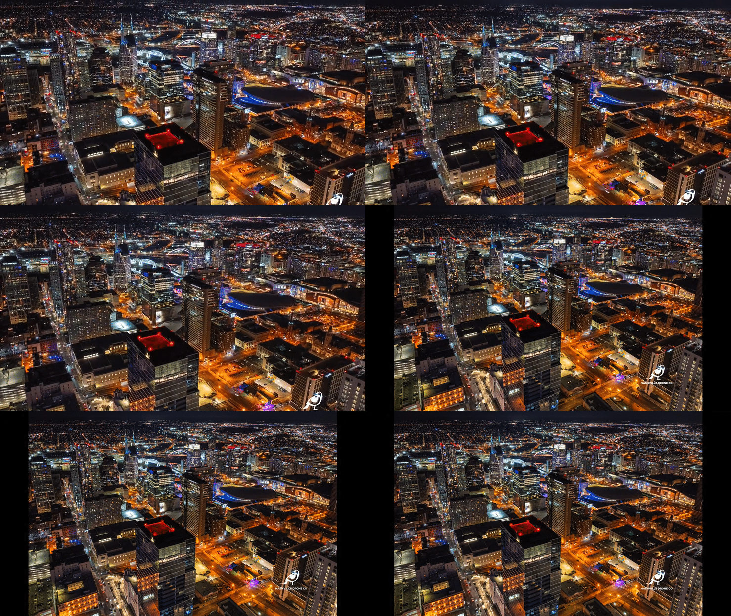
A buyer walks into a sales office on the ninth floor of a building that has not been built yet. They are standing in a model unit, looking at a rendering on the wall, and asking the one question every pre-sale condo buyer eventually asks. What will I actually see from my balcony. That question is harder to answer honestly than most people realize. A computer generated rendering can show anything an artist wants it to show. An actual photograph taken from the precise elevation and orientation of a specific unit cannot lie the same way, which is exactly why it carries so much more weight in a sales conversation, and exactly why getting it right matters more than most buyers or even most developers fully appreciate.
Why a Rendering Is Not Enough
Most high rise developments lean on architectural renderings for their marketing, and there is nothing wrong with that as a starting point. Renderings are useful for showing massing, materials, and overall design intent. But when a buyer wants to know what unit 1204 will actually look out onto once the building tops out, a rendering is an artist's interpretation, not a documented fact. Skylines shift depending on exact height and angle. A view that looks open and unobstructed in a rendering can turn out to have a neighboring rooftop or a construction crane sitting directly in the sightline once the real elevation is accounted for. This is where a real photograph, captured from the exact height and compass heading of the actual unit, becomes a far more persuasive and far more honest sales tool. It also protects the developer. A buyer who purchases based on an accurate future view photo has a much harder time coming back later with a complaint that the view they were sold does not match reality. Accuracy up front prevents disputes down the line, and that is worth more to a developer than a prettier but less precise image.
The Planning Comes Before the Flight
Getting an accurate future view shot is not something we show up and improvise on site. It starts well before a drone ever leaves the ground. Nashville Drone Co works directly with the development team to pull the actual floor plans and elevation data for the units the sales office wants to feature. That means knowing the finished floor height above grade for a specific unit, not just an approximate number pulled from a brochure. High rise construction documents typically include finished floor elevations for every level, and matching those numbers to a GPS altitude reading in the field is the difference between a photo that represents unit 1204 and a photo that represents a floor or two off from where it should be, which changes the sightline more than people expect.
Orientation matters just as much as height. A unit facing southeast toward the river is going to have a completely different view than a unit one floor up facing northwest toward the Gulch, even in the same building. Before any flight, we confirm the exact compass heading the unit's windows or balcony face, then plan the drone position to match both the altitude and the heading as closely as the airspace and site conditions allow. On some projects that means flying from the exact footprint of the future building, if the site is still under construction and airspace allows it. On others it means working from an adjacent vantage point and calculating the offset needed to represent the true sightline. None of this happens without direct coordination with the people who know the building best. Our founder, Keith Stancil, works hand in hand with development and marketing teams on these projects, reviewing plans, confirming which units the sales office wants to prioritize, and walking through what the final image needs to communicate before a single photo is taken. That upfront planning conversation is often the difference between a shoot that produces a usable sales tool and one that produces a nice photo that does not actually answer the buyer's question.
Why Blue Hour Is the Best Time to Shoot Downtown Nashville
Timing the shoot matters just as much as positioning the drone correctly, and this is where a lot of aerial photography falls short. Most people default to shooting in full daylight because it is the easiest light to work with. Daylight is fine for a straightforward property overview, but it is rarely the most compelling light for a downtown skyline shot, and it is almost never the light that sells a future view the way blue hour does. Blue hour happens in the window just after sunset, before full darkness sets in. The sky holds onto a rich, deep blue rather than going black, while the building lights across the skyline have had enough time to switch on and start glowing. That combination is what makes blue hour special. A daytime photo of downtown Nashville is flat by comparison, with buildings reading mostly as silhouettes against a bright sky and very little separation between structures. A blue hour photo has real depth. The illuminated windows and architectural lighting on buildings like the AT&T tower, Nashville Yards, and the buildings along the Cumberland create layers of light against that saturated blue sky, and the result looks genuinely alive in a way daylight cannot replicate. It is, honestly, one of the prettiest windows of the day to be in the air over this city, and it photographs that way too.
Blue hour is also a narrow window, typically less than half an hour depending on the season, which means the planning conversation described above has to happen well before the drone takes off. Often times multiple night shoots are necessary. Multiple night shoots present even more of a challenge is matching up the look of all shots.
Bracketed Exposures Capture What a Single Photo Cannot
Blue hour light is beautiful, but it is also technically demanding. The sky is bright compared to the ground, and the lit up buildings themselves span a huge range of brightness, from a softly lit residential tower to a stadium or venue running at full brightness. A single exposure cannot capture that entire range without losing detail somewhere, either blowing out the brightest lights or crushing the darker parts of the skyline into black.
That is why we shoot bracketed exposures on every blue hour shot. Rather than taking one photo, the camera captures a series of images of the same frame at different exposure settings, from darker to brighter. Those exposures are then combined in post-production, pulling the best detail from each one. The sky retains its color and gradient instead of going flat, the brightly lit building signage stays sharp instead of turning into a white blob, and the shadowed areas of the skyline hold real detail instead of disappearing into black. The result is a photo that looks the way the scene actually felt standing there, rather than the compressed, contrasty version a single exposure would have produced.
Night Photography and Why the Editing Matters as Much as the Shot
Once full darkness sets in, Nashville's skyline becomes its own kind of subject. The Batman Building, the bridges over the Cumberland, Nissan Stadium, and the dense cluster of lit up towers downtown all make for a genuinely striking night image, and it is one of our favorite conditions to shoot in. Night photography from the air comes with its own challenges though. Standard night shots tend to look noisy, lose color accuracy, and flatten out the subtle variations in light that make a skyline interesting. We rely on a bracketed capture and editing approach specifically built for night conditions, layering and blending exposures to recover detail and color depth that a typical nighttime photo loses. The difference shows up most in the details most people do not consciously notice but definitely feel, the visible texture in a building facade instead of a flat glow, distinct color temperature differences between warm and cool building lighting, and a sky that still shows some depth instead of going pure black.
Why This Level of Detail Is Rare
Most drone operators are not set up to do this kind of work, and it has nothing to do with the drone itself. Matching a specific unit's finished floor elevation to a real world GPS altitude, coordinating around a narrow blue hour window, and running a bracketed editing workflow on every image takes real time on both ends of the shoot, and it takes someone on the planning side who understands construction documents well enough to pull the right numbers in the first place. It is far easier, and far more common, for an operator to fly up at some approximate height that looks about right, snap a single daytime photo, and call it done. That photo might look fine hanging in a lobby, but it is not something a sales team can put in front of a serious buyer and stand behind.
The Result Is a View Buyers Can Trust
All of this planning, elevation matching, timing, and editing technique exists to serve one goal. When someone stands in a sales office and asks what they will see from their future balcony, the photo on the wall should be an honest answer, not just an appealing one. That is the standard Nashville Drone Co holds every high rise future view project to, and it is a big part of why developers across Nashville trust us with the images that actually help sell units, not just decorate a lobby.
A visit to the sales offices for the Paramount or The Pendry in downtown Nashville shows this work in person. Both feature future view photography captured by Nashville Drone Co, giving prospective buyers an accurate, on site look at what their unit's view will actually be once the building is complete, rather than relying on renderings alone.
Contact Nashville Drone Co to get your drone photography project started. info@nashvilledrone.co