How to Compare Drone Photography and Video Companies in Nashville
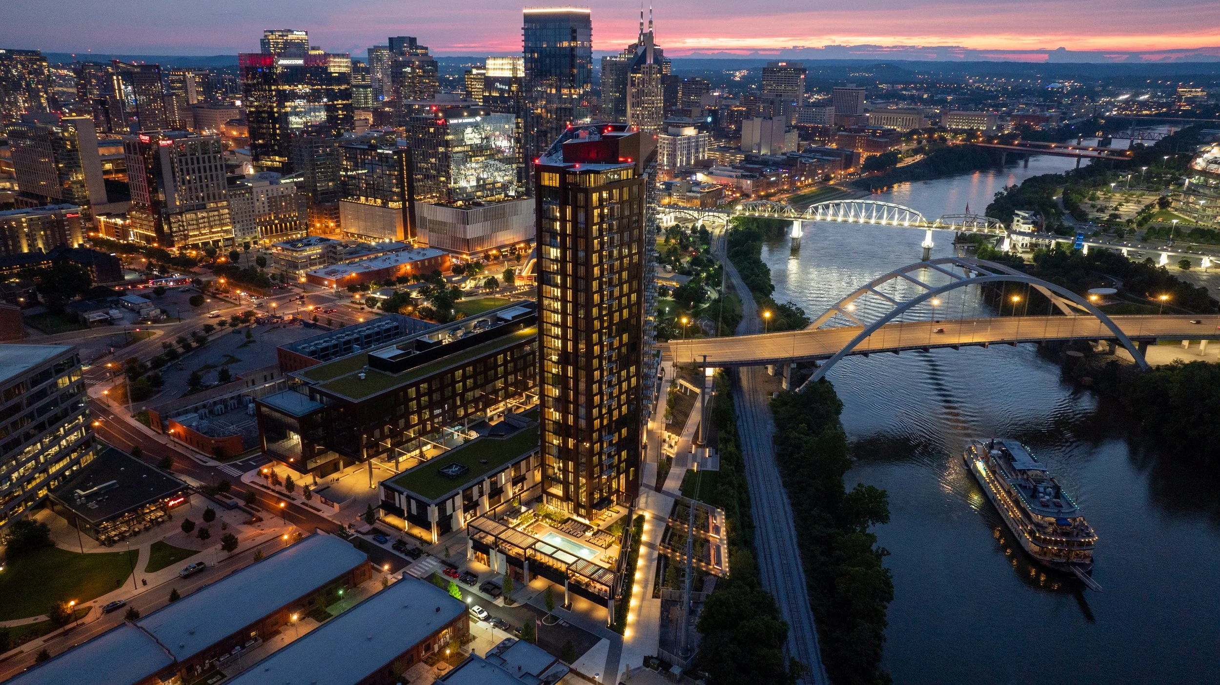
Anyone searching for a drone company in Nashville right now is looking at a page full of nearly identical service lists. Aerial photography. Construction documentation. Real estate video. Every site says roughly the same thing, in roughly the same order, using roughly the same language. None of that tells you what you actually need to know. Here's the one simple comparison that matters. Pull up each company's gallery and reel, side by side, and look at the work itself.
Forget the Service List. View the Reel and Gallery
A drone company's marketing page is written to be found. However, its gallery is where you find out if the company is any good. That's the part that can't be faked or filtered around, and it's the part most people skip past on their way to the contact form. Before hiring anyone, spend ten minutes actually watching the reel and scrolling the gallery.
5 questions to ask yourself About the Reel and Gallery
1) Are the photos sharp, high resolution, and genuinely clear?
Not "good enough for social media." Sharp enough to print on a banner in a sales office or a leasing lobby, because that's often exactly where these images end up.
2) What do the skies look like?
This is one of the fastest tells in the entire industry. A blown-out, flat white sky means the operator didn't manage exposure or didn't know how to correct it in post. A rich blue sky, or a well-shaded golden hour sky, means someone understood light before they ever launched the drone.
3) Does the video move like a film, or like a toy?
Cinematic drone footage has smooth, deliberate motion. Jerky stops, sudden direction changes, or footage that feels like someone is just flying a hobby drone around a building are signs of an operator without real production experience.
4) What does the color grading look like?
Flat, washed-out color or oversaturated, cartoonish color are both red flags. Good drone video has a color profile that looks intentional, consistent from shot to shot, and true to how the location actually looks.
5) Is exposure consistent, or all over the place?
Dark, muddy shadows in one shot and blown-out highlights in the next usually mean the operator is shooting on auto settings and hoping for the best, rather than dialing in exposure for each specific shot. None of this requires any technical background to spot. It just requires actually looking at the work instead of the words describing the work. What's sitting in a company's gallery right now is what will show up when the drone is over your project.
A Recent Example: The Paramount Photos
This exact scenario played out recently with a luxury high-rise client in Nashville. Early in the construction process, the developer's team hired a drone photography company to capture future views. The photos came back usable, in the sense that they were photos of the views. That was about the extent of it.
The client visited the sales office for the Paramount, the 60-story luxury high-rise from Giarratana Development in downtown Nashville, and saw Nashville Drone Co's photography project for Paramount on display. The difference in what they saw with the Paramount’s photos verses their photos was immediate. Sharper detail. Better composition. Skies that actually looked like skies. Color that was consistent from one image to the next instead of shifting depending on the time of day the photo happened to be taken. The client made the call to Nashville Drone Co not long after that visit to schedule new photos to be captured.
What separated the two sets of images wasn't luck. It came down to a handful of specific things: shooting at the right time of day for the light instead of whenever happened to be convenient, framing each shot with actual composition in mind rather than just centering the building in the frame, correcting exposure so skies stayed blue and shadows stayed detailed, and keeping color consistent across an entire batch of photos so a gallery or sales deck doesn't look like it was assembled from five different shoots. That consistency matters more than people expect going in. A single great photo is easy. A full set of consistently great photos, shot across different angles and times, is what separates a company that happens to own a drone from one that actually knows how to use it for marketing purposes.
Why Reel and Gallery Comparison Matters More for High-Rises and Commercial Projects
For a high-rise, construction site, or commercial real estate project, drone photography isn't decoration. It's often the primary sales and leasing tool before a building is even finished. Sales offices and leasing centers lean on these images to sell units and space that don't exist yet in any walkable form. If the photography is mediocre, it's not just an aesthetic problem, it's a sales problem.
In addition to the planned photos, Nashville Drone Co makes a point of capturing a standout image from a key elevation and view on every high-rise project, a single frame that sums up the prime view a resident or tenant could actually have. That one photo tends to become the anchor image for pre-sales materials, leasing brochures, or marketing decks, because it answers the exact question a buyer or tenant is asking: what will I actually see from up here?
Nashville Drone Co works across high-resolution stills, high-resolution 360 degree panoramic photography, construction progress documentation for towers still under construction, and architectural photography of finished buildings. The through line across all of it is the same standard: images clean and consistent enough to hand directly to a sales team without needing a disclaimer about lighting or quality.
What Clients Have Said About Nashville Drone Co
Feedback from recent projects has centered on a similar set of themes: reliability, quality, and speed of turnaround.
"Nashville Drone Co delivered exceptional drone video and aerial photography for our Paramount project. Nashville Drone Co owner, Keith Stancil, expertly captured stunning future condo views that are instrumental in our pre-sales and marketing efforts. His responsiveness, fast turnaround and creative approach to video marketing made the process seamless. We highly recommend Nashville Drone Co for top-tier aerial visuals." - Tony Giarratana of GIARRATANA, LLC, developer of the Paramount
"Nashville Drone Co is now our go-to drone video and photo company. What an absolute masterclass in service. Our team could not be more satisfied with their work." - Katie Garland, VP of Brokerage & Marketing at Charles Hawkins Co Commercial Real Estate
"Recently had the opportunity to collaborate with Keith Stancil/Nashville Drone Co on some drone content in Nashville, and it was a fantastic experience. From project alignment, scheduling, responsiveness, through to creative direction/feedback, Keith's professionalism and quality of work was appreciated." - Willow Mair of Axiom Builders, working on The Motley Nashville
"Nashville Drone Co did an incredible job. The visibility captured in the drone footage of the construction site allowed me and my team to have an incredible insight to the weekly progress made as well as help us track and ensure that safety protocol was constantly being adhered to and quality of erosion control was being up kept throughout the project. The quick turnaround time also came in handy as were using this footage for multiple reasons on a weekly basis. Highly recommend." - Ben Melton of McCrory Construction
Beyond the Gallery: Four Follow-Up Questions
Once a gallery has passed the eye test, there are a few practical questions worth asking before signing off on a drone company for a construction or real estate project.
1) How fast is turnaround?
Construction documentation is often needed on a weekly basis to track progress, monitor safety compliance, and keep erosion control and site conditions on record. A company that takes two weeks to deliver files isn't useful for a weekly reporting cycle, no matter how good the images look once they finally arrive.
2) Are they actually certified to fly commercially?
FAA Part 107 certification is the baseline requirement for any commercial drone operation in the United States, and it matters even more near a downtown corridor or an active job site with cranes and other aircraft in the airspace. Any company doing this work professionally should be able to speak to their certification and their understanding of airspace restrictions without hesitation.
3) Do they understand the marketing side, not just the flying side?
There's a real difference between someone who can pilot a drone competently and someone who understands how a photo is going to be used in a sales deck or a leasing brochure. The best work in this space tends to come from people who think about composition and story the same way a photographer or marketer would, not just a pilot checking boxes on a flight log.
4) Is their portfolio specific to the type of project involved?
A company with a strong gallery of wedding or landscape drone shots isn't necessarily the right fit for a 60-story high-rise or an active concrete pour. Look for a track record with the kind of project actually being planned, whether that's a residential tower, a commercial retail space, or a construction site under a tight documentation schedule.
None of these questions replace the gallery test. They're a second layer, useful once a company's actual work has already earned a closer look.
The Bottom Line
Skip the service descriptions and go straight to the gallery. Look at the skies. Look at the color. Watch whether the video moves smoothly or jerks around. Check whether the photos look consistent from one to the next, or like they were shot on five different settings across five different days. Whatever quality is sitting in that gallery today is exactly what will show up on-site. The Paramount comparison made that obvious to one client already. It tends to become obvious to anyone else who takes the time to actually look before they hire.
Contact Nashville Drone Co to view actual top level drone video and photography. info@nashvilledrone.co
Who Offers High End Drone Photography Near Me in the Nashville area?
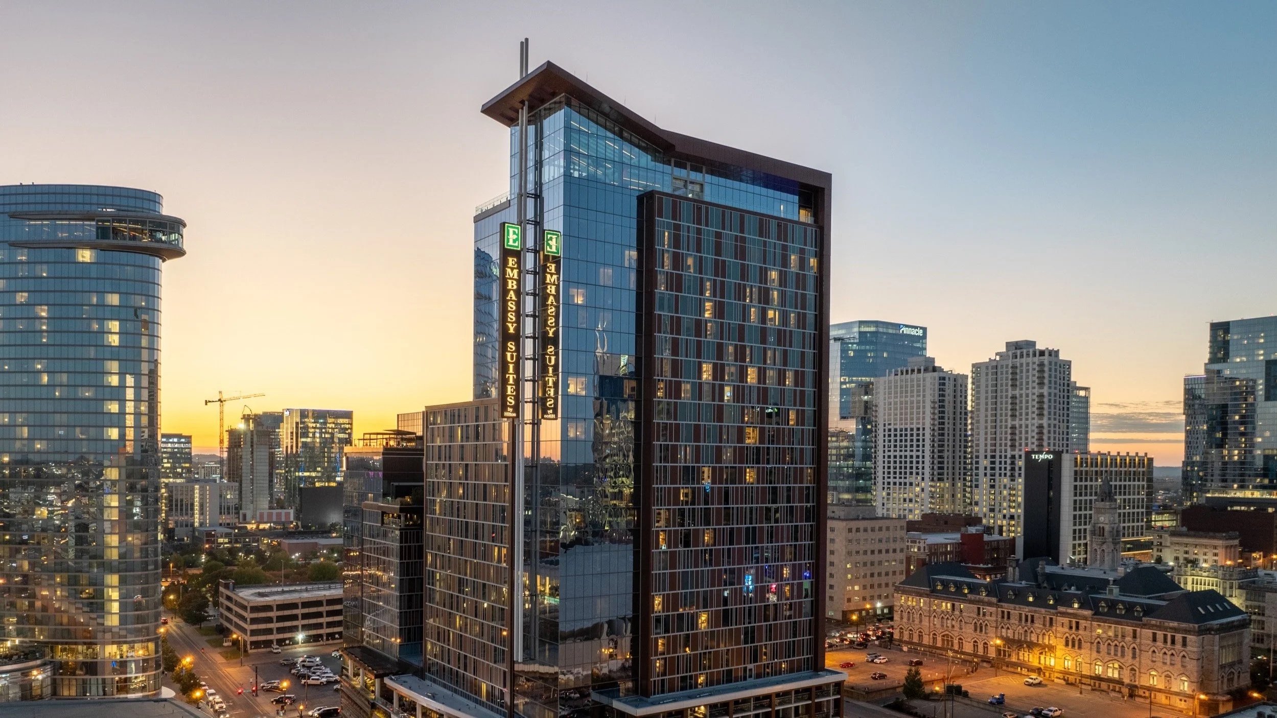
Nashville Drone Co Nashville Embassy Suits Photo
If you searched "who offers high end drone photography near me" because you need images that actually move product, close deals, or land press coverage, you already know that not every drone operator can deliver that. Anyone with a consumer drone and an app can take a photo from up high. Far fewer can walk into a 60 story luxury condo tower under construction, understand what a buyer standing at their future kitchen window will actually see, and capture that view with the precision a real estate sales team can put directly into a marketing deck. That distinction is exactly why Giarratana Development, the developer behind some of Nashville's most recognizable high-rise projects, chose Nashville Drone Co to photograph the views from every floor of Paramount Tower, one of downtown Nashville's tallest residential buildings.
What "High End" Actually Means in Drone Photography
The phrase gets used loosely. For Nashville Drone Co, high end photography is not about flying higher or owning more expensive equipment, although the gear matters. It is about the planning, the technical execution, and the editing that turns a raw aerial capture into something a luxury buyer would trust enough to put a deposit down on. Founder Keith Stancil built the company on that idea, bringing over two decades of entertainment marketing experience into a business that treats every project like a campaign asset, not a snapshot. Nashville Drone Co's marketing background is woven into every photo the team takes. Every image is intentionally captured to sell property, whether that property is a condo, a home, or a commercial development.
Nashville Drone Co’s specialty is hi-res aerial photography for luxury high rise developers, commercial real estate, and residential clients across Middle Tennessee. That focus shows up from the first conversation with a client. The question is never just what can we photograph. It is what does this image need to accomplish for the sale.
Legally Cleared to Shoot Where Others Can't
Downtown Nashville sits close to restricted and controlled airspace, and tall construction sites bring their own regulatory complications. Nashville Drone Co secures FAA flight waivers to legally shoot in restricted areas, allowing the team to fly projects that many operators would have to turn down or attempt without proper authorization. For a developer, that matters. An unauthorized flight can put a project's marketing timeline and a company's reputation at risk. Working with a fully credentialed, Part 107 certified operator who understands the waiver process removes that liability entirely.
The Paramount Tower Project: Photographing 60 Floors of Future Views
When Giarratana Development set out to build a high tech sales office for Paramount Tower, they needed something buyers could not get anywhere else: an honest, high-resolution preview of exactly what they would see from their specific floor, long before the building was finished enough to walk through.
Nashville Drone Co captured both high-resolution still images and full 360 degree panoramic views from each floor of the tower, giving the sales office a library of visuals that let a potential buyer stand in front of a screen and see, floor by floor, the skyline, the river, the hills, and the neighborhoods visible from their unit. This was not a matter of sending a drone up and hoping for a usable shot. Every floor required its own plan.
Getting the Elevation Right
Before a single photo was taken, Nashville Drone Co worked directly with Paramount's project managers and engineers to calculate the precise elevation an average height person would be viewing from on each individual floor. A view captured a few feet too high or too low can misrepresent what a buyer will actually experience once they move in, and in a luxury market, that kind of inaccuracy is not something a developer can afford. Getting this detail right meant coordinating construction data, floor plans, and finished ceiling heights, then translating all of it into exact flight elevations for dozens of separate shoots.
Timing the Light
Nashville Drone Co also consulted with the Paramount team on the best time of day to capture each set of images. Light changes everything in a skyline photo. The angle of the sun, the shadows cast by neighboring buildings, and the color of the sky all affect how a view reads to someone seeing it for the first time. Rather than shooting on a fixed schedule for convenience, the team planned capture windows around what would present each direction and floor in its best possible light.
Shooting for Precision, Not Convenience
Once conditions were right, the technical work began. Nashville Drone Co used a bracketed photography technique for every shot, capturing multiple exposures of the same view and blending them to preserve detail in both the brightest sky and the darkest shadow. This is standard practice in professional real estate and architectural photography, but it is labor intensive and easy to skip, and skipping it is often the difference between a photo that looks like a listing snapshot and one that looks like it belongs in a design magazine.
After the shoot, every image went through detailed post production. Exposure, color balance, and clarity were refined until each photo represented the view as accurately and attractively as possible. For a project of Paramount's scale, that meant editing hundreds of images across dozens of floors, all while keeping a consistent look across the entire collection so the sales office presentation felt cohesive rather than assembled from mismatched shoots.
More Than Marketing Photography
While projects like Paramount Tower highlight the sales and marketing side of the business, Nashville Drone Co also excels at architectural documentation and construction site progress and inspection work. Developers and builders use aerial photography throughout a project's timeline, not just at the marketing stage, to track progress against schedule and document site conditions for stakeholders and investors. That dual capability, marketing grade imagery paired with technical documentation, is part of why the company has become a go-to resource on multiple projects rather than a one-time vendor.
Why This Level of Detail Matters for Luxury Buyers
Buyers in the luxury condo market are not just purchasing square footage. They are purchasing a view, a lifestyle, and a level of confidence that what they are being shown is what they will actually get. That audience notices when an image looks slightly off, when the light is wrong, or when a view seems exaggerated. High-resolution accuracy is not a bonus feature for this kind of buyer. It is a baseline expectation, and it is the gap Nashville Drone Co fills by treating every floor of a building like its own individual project, with its own elevation, lighting plan, and editing pass.
From Sales Office to Nashville Business Journal
The impact of this work has extended well beyond Paramount's sales office. Nashville Drone Co's aerial photography has been featured in the Nashville Business Journal and in major marketing campaigns tied to Nashville's luxury high rise condos and hotels, putting the work in front of investors, industry professionals, and prospective buyers following Nashville's high-rise development boom. That kind of recognition happens when the photography is strong enough to stand on its own as visual storytelling about a building, not just a marketing add-on.
A Track Record Beyond Paramount
Giarratana Development is far from the only name relying on Nashville Drone Co's high end aerial work. The company is highly reviewed by leading land developers and high rise builders in Nashville, with ongoing relationships across Middle Tennessee's construction and development landscape, including McCrory Construction, Charles Hawkins Co, Axiom Builders, Redeavor Group and SomeraRoad. Each project brings its own requirements, but the approach stays the same: understand what the client needs the photography to accomplish, then build a plan around delivering exactly that, rather than a generic aerial package.
For a developer like Giarratana, working with a team that already understands the pressure of selling units in a high-rise before the building is finished makes a real difference. There is no learning curve, no explaining why elevation accuracy matters, and no need to walk a photography team through what a sales office presentation actually requires.
See the Difference for Yourself
The easiest way to understand the gap between Nashville Drone Co and other drone operators in the area is to compare galleries and portfolios directly. A big difference in Nashville drone photography and competitors can be seen quickly this way. Set a Paramount Tower panoramic view next to a typical listing photo taken from a consumer drone, and the difference in elevation accuracy, exposure detail, and overall polish becomes obvious immediately.
What to Look for When Searching "High End Drone Photography Near Me"
If you are evaluating drone photography for a project where the images need to do real work, whether that is selling condo units, marketing a commercial development, or documenting construction progress for investors and press, a few things separate high end providers from everyone else offering aerial photos in Nashville.
Look for a team that plans around your specific goals rather than offering a “one size fits all” package. Ask how they approach lighting and timing, since the difference between a flat midday shot and a photo captured under the right conditions is significant. Find out whether they use bracketed exposure techniques and detailed post production, since raw drone footage rarely looks finished straight out of the camera. Confirm they hold the proper FAA certification and waivers to fly legally in restricted airspace, and consider whether they have experience working directly with project managers, engineers, and sales teams.
Nashville Drone Co has built its reputation on exactly that kind of work. The Paramount Tower project is one example of what happens when aerial photography is treated as a strategic marketing tool rather than an afterthought, and it is why land developers and high rise builders across the Nashville area continue to turn to the team when the images need to do more than just look good. They need to sell
Contact Nashville Drone Co for your high end drone photography needs. info@nashvilledrone.co
What Drone Companies Offer 360 Degree Panoramic Photography Near Me?
As cities grow upward and skylines become more competitive, real estate developers are constantly searching for ways to showcase what makes their properties special. One of the most powerful tools emerging in modern real estate marketing is 360 degree panoramic drone photography. If you have recently searched for drone 360 degree panoramic photography services near me, you are likely looking for a professional aerial imaging company that can capture immersive views of buildings, construction sites, and city skylines.
In Nashville and across the Southeast, one company that specializes in this advanced form of aerial imaging is Nashville Drone Co. The company focuses heavily on high resolution aerial imagery, cinematic drone video, and interactive panoramic visuals designed specifically for developers, architects, and marketing teams.
This article explains what 360 degree panoramic drone photography is, why developers rely on it, and how Nashville Drone Co helps high rise projects sell luxury condos before the buildings are even finished.
Understanding 360 Degree Panoramic Drone Photography
Traditional aerial photography captures a single perspective. While these images can look dramatic, they still limit what the viewer can see. 360 degree panoramic drone photography takes a different approach. Instead of capturing one image, a drone collects dozens of photographs from a single aerial position. These images are stitched together to form a seamless sphere around the camera. When viewers interact with the image, they can rotate and explore the full horizon in every direction. The result is an immersive experience that allows people to:
Look north, south, east, and west from the same viewpoint
Zoom into skyline details and landmarks
Compare how the view changes during different times of day
Experience the environment as if standing in that location
For real estate developers, this technology solves a major marketing challenge. Buyers want to know exactly what the view will look like from their future home. 360 degree Panoramic drone photography allows them to see it long before construction finishes.
Why Developers Need Drone Panoramic Photography
High rise buildings sell more than square footage. They sell views. When someone purchases a luxury condo on the 30th or 50th floor, the surrounding skyline becomes part of the product. But during early development phases, those views are impossible to show using traditional photography. This is where 360 degree drone imagery becomes extremely valuable. Panoramic aerial photography gives potential buyers the ability to explore the city from the exact height where their future home will be located. Instead of imagining the view from architectural renderings, buyers can interact with a real world panoramic environment captured by a drone. Developers use these visuals because they deliver several powerful marketing advantages:
1. They Reduce Buyer Uncertainty
Pre-construction sales require trust. Buyers need confidence that the view they are promised will match reality. Interactive panoramic imagery helps remove that uncertainty.
2. They Increase Engagement
Interactive visuals naturally hold attention longer than static images. Viewers can rotate and explore the panorama, creating a stronger emotional connection.
3. They Strengthen Sales Presentations
Panoramic city views can be displayed on websites, touchscreen kiosks, virtual reality systems, and digital presentations.
4. They Differentiate a Development
In competitive urban markets, projects that show real views stand out against those relying only on renderings.
Nashville Drone Co and the Rise of Skyline Visualization
A leader in this space is Nashville Drone Co, a company that focuses on aerial storytelling for real estate, construction, and development projects. The company has become known for producing interactive 360 degree city views that allow people to explore the skyline as if they were standing hundreds of feet above the ground. Their work is currently being showcased at Nashville based Giarratana Development’s sales office for their new Paramount tower.
Each panoramic image places the viewer in the center of the scene. From that position, they can rotate around the city, zoom into landmarks, and explore the urban landscape in high resolution. These immersive visuals transform the way developers present future properties. Instead of describing the view from a penthouse balcony, developers can now show it in a way that feels real.
Capturing Future Views for High Rise Condos
One of the most fascinating applications of drone panoramic photography is future view capture. When a developer plans a tall building, the project often begins with an empty lot or a partially completed structure. At that stage, the actual view from the upper floors does not yet exist. Nashville Drone Co solves this problem by flying drones to the exact altitude where future floors will be located. By positioning the drone at specific heights that correspond to planned levels of the building, the company can photograph the skyline from the same perspective that future residents will see from their windows.
These images allow developers to create realistic visualizations of:
Penthouse views
Balcony perspectives
Rooftop amenities
Office tower outlooks
The technique essentially allows people to experience the future before construction is finished. Developers can show buyers what they will see when looking out from their living room, kitchen, or terrace.
The Role of 360 Degree Panoramic Drone Views in Pre Construction Sales
Selling a condo before the building exists can be challenging. Architectural renderings and floor plans help buyers understand the layout of a property, but they do not fully communicate the emotional experience of living in the space. Interactive drone panoramas help bridge that gap. When buyers can rotate a panoramic skyline image captured from the height of their future unit, they gain a realistic sense of the environment around them. This creates a powerful marketing advantage. Sales teams often integrate these panoramic images into:
digital sales presentations
touchscreen displays in sales centers
virtual reality experiences
interactive project websites
Because buyers can explore the city visually, they become more confident in their purchase decision.
Real Projects Using Drone Panoramic Visualization
High rise developments in Nashville increasingly rely on aerial imaging to communicate their vision. One notable example involved the Paramount Tower, a luxury tower development where developer Giarratana needed to demonstrate the dramatic skyline views from upper floors. To solve this challenge, the development team partnered with Nashville Drone Co to capture aerial imagery and 360 degree panoramic visuals from the planned heights of the future building. These visuals allowed potential buyers to rotate and explore the surrounding cityscape in every direction. The imagery helped Giarratanas’s sales and marketing teams show exactly how the building would relate to nearby landmarks and skyline features.
In addition to panoramic photography, drone video and aerial still images were also used in promotional materials, news coverage, and digital marketing campaigns. This combination of immersive imagery and storytelling helped communicate the scale and ambition of the project.
How Nashville Drone Co Captures 360 Degree Aerial Panoramas
Creating a seamless 360 degree aerial panorama requires advanced planning and technical expertise. The process typically includes several key steps.
Flight Planning
Before launching the drone, pilots study the architectural plans of the development. This allows them to determine the exact altitude needed to match the height of future floors.
Precision Drone Capture
During the flight, drones capture a sequence of high resolution images covering every direction around the aircraft. This ensures complete coverage of the skyline.
Image Stitching and Editing
After capture, the images are carefully stitched together to create a seamless panoramic environment. Color correction and alignment adjustments ensure a natural result.
Interactive Delivery
The final panoramic image is delivered in an interactive format that allows viewers to drag, rotate, and zoom around the city.
The end result is an immersive visual experience that feels closer to standing on a balcony than looking at a photograph.
HDR Bracketed Photography
For hi-resolution still views, Nashville Drone Co uses bracketed photography. To capture the full dynamic range of the scene, multiple exposures are taken and blended together. This technique helps preserve details in bright skies and darker buildings.
Marketing Advantages for Developers
For developers investing millions of dollars into new towers and residential projects, the right visuals can significantly impact sales. 360 degree panoramic drone imagery provides several measurable advantages.
Faster Pre Sales
When buyers can see real skyline views from their future unit, hesitation often decreases. This helps projects secure early deposits before construction finishes.
Higher Buyer Confidence
Interactive visuals provide transparency. Buyers know exactly what they are getting.
Premium Positioning
Luxury developments benefit from marketing that matches the scale and ambition of the project. High resolution aerial panoramas elevate the brand of the development.
Greater Digital Engagement
Interactive media tends to generate longer engagement times on websites and digital presentations.
Beyond Condos and High Rise Buildings
While high rise development is a major use case, panoramic drone photography can serve many industries.
Companies use this technology for:
commercial real estate marketing
tourism promotion
hospitality marketing
architecture visualization
construction documentation
city planning presentations
Any situation where perspective and location matter can benefit from immersive aerial imagery.
Why Businesses Search for Drone 360 Degree Panoramic Photography Near Me
Local expertise is extremely important in aerial photography. Professional drone operators must understand airspace regulations, weather patterns, and the geography of the city they are photographing. A local company also understands how a skyline evolves over time and which viewpoints matter most for marketing.. That is why developers and real estate professionals often search for drone 360 degree panoramic photography services near me. Working with a specialized provider like Nashville Drone Co ensures the imagery reflects both technical precision and a deep understanding of the city.
The Future of Real Estate Visualization
The way properties are marketed is rapidly changing. Today’s buyers expect immersive digital experiences. Static images alone no longer communicate the full value of a location. Drone based 360 degree panoramic photography is becoming one of the most powerful tools for real estate marketing because it connects architecture with the surrounding environment. Instead of imagining what life might look like in a future building, buyers can explore the skyline in real time. For developers in growing cities like Nashville, this technology helps transform an empty construction site into a vivid vision of the future.
Final Thoughts
If you are searching for drone 360 degree panoramic photography services near you, understanding the capabilities of this technology is essential.
Panoramic aerial imagery allows developers, architects, and marketers to present projects in a way that feels immersive and real. By capturing skyline views from the exact heights of future buildings, Nashville Drone Co helps transform architectural plans into interactive experiences. For high rise developers, that capability can make the difference between asking buyers to imagine a view and actually letting them see it. Contact Nashville Drone Co for a quote on 360 degree panoramic photos. info@nashvilledrone.co