Best Rated Camera Drones in 2026, Ranked by a Nashville Drone Company
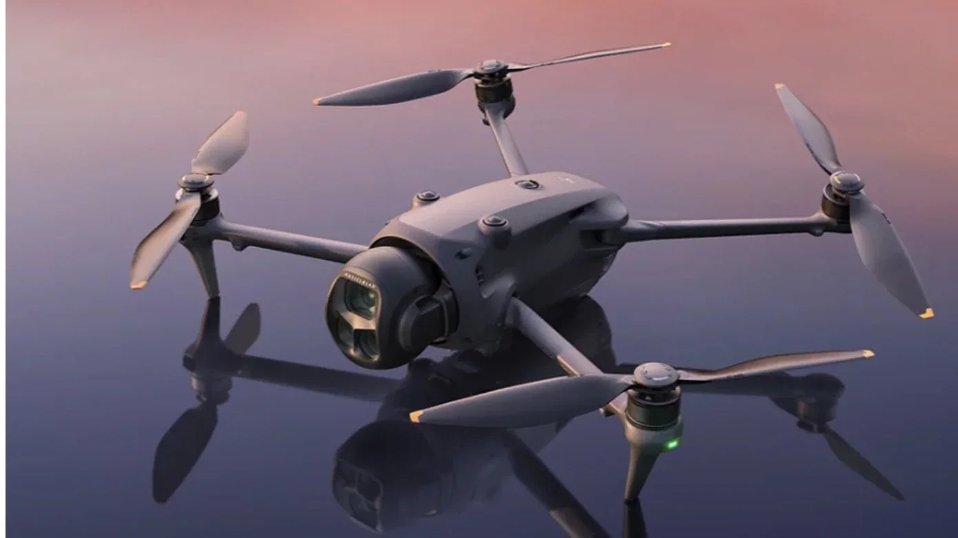
Spec sheets make every drone sound impressive. Paid shoots sort them out quickly. Nashville Drone Co flies commercial work across Middle Tennessee, including film, music videos, marketing video and construction progress programs on downtown high-rises, so the drones we use every week and the ones that stay in the case tell us a lot. This ranking blends two sources: what independent review outlets found in testing, and what our team at Nashville Drone Co has learned flying these aircraft on real jobs. When a claim comes from a reviewer, we name the outlet. When it comes from our own work, we say so.
Here is how each drone ranks, with our rating beside it.
| Rank | Drone | Nashville Drone Co Rating | Best For |
|---|---|---|---|
| 1 | DJI Mavic 4 Pro | 9.7/10 | Stills, 6K video, 360 panoramas |
| 2 | DJI Mavic 3 Pro | 9.5/10 | Film, broadcast, construction |
| 3 | DJI Mini 5 Pro | 7.5/10 | Travel, calm-weather shoots |
| 4 | DJI Avata 2 | 6.5/10 | FPV motion shots |
| Hall of Fame | DJI Mavic Air 2 | Not scored | The drone that started it all |
1. DJI Mavic 4 Pro: Top Rating (9.7/10)
The Mavic 4 Pro takes the top spot on our list and on the review sites we checked. Tom's Guide gave it five-star performance marks and named it the best consumer drone you can buy, citing 100MP Hasselblad stills and smooth 6K and 4K video at 60 frames per second. TechRadar also awarded it Editor's Choice, and Fstoppers scored it 26 out of 30 (87 percent) after real-world photography tests, while noting it will not replace a medium format camera.
A few details are worth knowing before you buy. Pix-Pro points out that the 100MP main sensor uses a Quad Bayer layout, so its native resolution is closer to 25MP, with the full 100MP mode built from that. The three lenses cover 28mm, 70mm and 168mm, and DroneXL's long-term review singled out the two telephoto options as the reason it keeps choosing this drone. The gimbal also rotates a full 400 degrees, according to DroneXL's hands-on testing.
In our hands, the 100MP files give us generous cropping room, and the 360 degree panoramas are excellent. We rely on them for construction progress documentation, where one panorama can show an entire site. The tradeoff is size. TechRadar noted the aircraft weighs just over one kilogram, so this is not a jacket pocket drone.
2. DJI Mavic 3 Pro: Close Second (9.5/10)
The Mavic 3 Pro has been the workhorse at Nashville Drone Co. It has flown on film projects, music videos, marketing videos and construction progress programs. It captured the Billion Dollar Photo used in marketing for Paramount Tower, and it was the drone used in a live broadcast of the Leagues Cup Final.
Reviewers back up that reputation. TechRadar gave it Editor's Choice and called it the most versatile Mavic to date, pairing a 20MP Four Thirds main camera with 70mm and 166mm telephoto cameras. Video goes up to 5.1K at 200Mbps, with Apple ProRes options for professional workflows. Amateur Photographer added a practical note: the two telephoto cameras have fixed apertures, which makes ND filters essential for video.
So why second? The Mavic 4 Pro offers more resolution and 6K video. The Mavic 3 Pro offers something a spec sheet cannot show, which is a long record of getting the shot on deadline. When a broadcast or a client launch depends on one flight, that history counts.
3. DJI Mini 5 Pro: Great Camera, Wind Limits (7.5/10)
On camera quality alone, the Mini 5 Pro would rank higher. Fstoppers highlights a 50MP, 1-inch sensor in a sub 250 gram body, plus 4K video at up to 120 frames per second. That is a remarkable amount of imaging for a drone this small.
Wind is where it falls short for our work. DJI rates it for winds up to 12 meters per second, roughly 27 miles per hour, and Tom's Guide reported it stayed steady in 21 mph wind. Fstoppers, though, observed that it still wobbles in strong wind, which is expected for an aircraft this light. Our standard is stricter than a casual flight. In winds over 15 mph, the Mini 5 Pro does not give us footage we are comfortable delivering to a paying client, and wind is usually stronger at the heights we fly for building projects. For travel and calm days it is a great choice. For client work in Tennessee weather, it stays a second aircraft.
4. DJI Avata 2: Fun FPV, Post-Heavy Footage (6.5/10)
The Avata 2 is a fun FPV drone. According to The Drone Girl, it carries a 1/1.3-inch, 12MP camera behind a 155 degree ultra-wide lens, shooting 4K at 60 frames per second, and the 10-bit D-Log M color mode gives editors room to work.
The camera is not its strength, though. TechGearLab points out that it uses a single-axis gimbal, so stabilization trails drones with three-axis gimbals. In our experience, the footage needs heavy lifting in post editing before it looks great. Where the Avata 2 earns its place is in immersive moves through tight spaces that a Mavic cannot attempt. Budget extra editing time every time it flies.
Hall of Fame: DJI Mavic Air 2
Every company has an origin story, and ours starts with the Mavic Air 2. When it launched in April 2020, PetaPixel described a 48MP half-inch Quad Bayer sensor, 4K video at 60 frames per second and a 34 minute battery in a 570 gram airframe. CineD noted it was the first Mavic to record 4K at 60 frames per second at 120Mbps, beating the pricier Mavic 2 Pro on that spec.
That was enough to start a business on. The Air 2 flew on the Wynonna Judd film Between Hell and Hallelujah and on multiple major label music videos, and it got Nashville Drone Co off the ground. It is a good reminder that a capable camera in the hands of a prepared pilot goes a long way.
How to Choose the Right Camera Drone
Start with the work, not the ranking. Four questions narrow the field quickly.
1) What does the deliverable need?
Large-sensor drones like the Mavic 4 Pro and Mavic 3 Pro hold detail in bright skies and deep shadows, which matters for marketing video and architecture. Smaller sensors can handle social content.
2) What wind will you fly in?
Lighter aircraft get pushed around first. If you regularly fly above 15 mph, weight matters as much as camera specs.
3) How much editing time do you have?
A drone with a superb camera saves hours downstream. A weaker camera moves that cost into post production.
4) How portable does it need to be?
The Mini 5 Pro weighs under 250 grams and travels easily. The Mavic 4 Pro is a larger aircraft that needs more room.
Buying a DJI Camera Drone in the US
Availability changed in December 2025, when the FCC updated its Covered List to include foreign-produced drones. UAV Coach reports that the update names DJI and Autel among others. According to the FCC's fact sheet, the decision does not affect drones people already own, and retailers can keep selling models approved earlier, because the restrictions apply to new device models. UAV Coach adds that no grounding order or remote disablement has been placed on drones already in use. Rules and stock can shift, so confirm current availability with an authorized retailer before you buy.
Frequently Asked Questions
What is the best rated camera drone right now?
Among the drones covered here, the DJI Mavic 4 Pro holds the top spot, supported by Editor's Choice awards from TechRadar and Tom's Guide and by our own 9.7 out of 10 rating.
Is the Mavic 3 Pro still worth buying?
For teams that value a proven record, yes. It earned Editor's Choice from TechRadar and remains a dependable tool for film, marketing and construction work. If you need 100MP stills or 6K video, step up to the Mavic 4 Pro.
Do I need a license to fly a drone commercially?
In the United States, yes. Commercial pilots need an FAA Part 107 remote pilot certificate. Keith Stancil, founder of Nashville Drone Co, holds one.
The Bottom Line
If you want the strongest single camera drone on this list, choose the Mavic 4 Pro. If you want a proven production aircraft with a record behind it, the Mavic 3 Pro is nearly as good and has earned its place in our case. Choose the Mini 5 Pro for travel and calm days, the Avata 2 for FPV motion, and remember that no camera makes up for a pilot who plans the shot, checks the wind and knows the airspace.
Work With Nashville Drone Co
Nashville Drone Co provides drone photography and video across Middle Tennessee. Founded by Keith Stancil, an FAA Part 107 certified pilot with over two decades of professional entertainment marketing experience, the company covers everything from construction progress programs to music videos. Planning a shoot? Reach out via our contact page and tell us what you need to capture.
Sources
Tom's Guide, DJI Mavic 4 Pro review: https://www.tomsguide.com/cameras-photography/drones/dji-mavic-4-pro-review
TechRadar, DJI Mavic 4 Pro review: https://www.techradar.com/cameras/drones/dji-mavic-pro-4-review
Fstoppers, Mavic 4 Pro review: https://fstoppers.com/reviews/dji-mavic-4-pro-review-best-drone-photographers-711582
Pix-Pro, Mavic 4 Pro review: https://www.pix-pro.com/blog/mavic-4-pro-review
DroneXL, Mavic 4 Pro test results: https://dronexl.co/2025/05/13/dji-mavic-4-pro-review-test-results/
DroneXL, Mavic 4 Pro long-term review: https://dronexl.co/2026/02/05/dji-mavic-4-pro-drone-long-term-review/
TechRadar, DJI Mavic 3 Pro review: https://www.techradar.com/reviews/dji-mavic-3-pro-review
Amateur Photographer, DJI Mavic 3 Pro review: https://amateurphotographer.com/review/dji-mavic-3-pro-review/
Fstoppers, DJI Mini 5 Pro review: https://fstoppers.com/reviews/review-dji-mini-5-pro-drone-redefines-mini-standard-714487
Tom's Guide, Mini 5 Pro vs Mini 4 Pro: https://www.tomsguide.com/cameras-photography/drones/dji-mini-5-pro-vs-dji-mini-4-pro-clear-winner
The Drone Girl, Avata 2 review: https://www.thedronegirl.com/2024/04/11/avata-2-review/
TechGearLab, DJI Avata 2 review: https://www.techgearlab.com/reviews/cool-gadgets/drones/dji-avata-2
PetaPixel, Mavic Air 2 announcement: https://petapixel.com/2020/04/27/dji-unveils-the-mavic-air-2-with-48mp-sensor-4k-60p-video-and-34-minute-battery/
CineD, Mavic Air 2 review: https://www.cined.com/dji-mavic-air-2-review-first-look-4k-60p-1080p-240fps/
FCC fact sheet on the Covered List update: https://docs.fcc.gov/public/attachments/DOC-416839A1.pdf
UAV Coach, DJI ban explainer: https://uavcoach.com/dji-ban/
What Drone Companies Offer 360 Degree Panoramic Photography Near Me?
As cities grow upward and skylines become more competitive, real estate developers are constantly searching for ways to showcase what makes their properties special. One of the most powerful tools emerging in modern real estate marketing is 360 degree panoramic drone photography. If you have recently searched for drone 360 degree panoramic photography services near me, you are likely looking for a professional aerial imaging company that can capture immersive views of buildings, construction sites, and city skylines.
In Nashville and across the Southeast, one company that specializes in this advanced form of aerial imaging is Nashville Drone Co. The company focuses heavily on high resolution aerial imagery, cinematic drone video, and interactive panoramic visuals designed specifically for developers, architects, and marketing teams.
This article explains what 360 degree panoramic drone photography is, why developers rely on it, and how Nashville Drone Co helps high rise projects sell luxury condos before the buildings are even finished.
Understanding 360 Degree Panoramic Drone Photography
Traditional aerial photography captures a single perspective. While these images can look dramatic, they still limit what the viewer can see. 360 degree panoramic drone photography takes a different approach. Instead of capturing one image, a drone collects dozens of photographs from a single aerial position. These images are stitched together to form a seamless sphere around the camera. When viewers interact with the image, they can rotate and explore the full horizon in every direction. The result is an immersive experience that allows people to:
Look north, south, east, and west from the same viewpoint
Zoom into skyline details and landmarks
Compare how the view changes during different times of day
Experience the environment as if standing in that location
For real estate developers, this technology solves a major marketing challenge. Buyers want to know exactly what the view will look like from their future home. 360 degree Panoramic drone photography allows them to see it long before construction finishes.
Why Developers Need Drone Panoramic Photography
High rise buildings sell more than square footage. They sell views. When someone purchases a luxury condo on the 30th or 50th floor, the surrounding skyline becomes part of the product. But during early development phases, those views are impossible to show using traditional photography. This is where 360 degree drone imagery becomes extremely valuable. Panoramic aerial photography gives potential buyers the ability to explore the city from the exact height where their future home will be located. Instead of imagining the view from architectural renderings, buyers can interact with a real world panoramic environment captured by a drone. Developers use these visuals because they deliver several powerful marketing advantages:
1. They Reduce Buyer Uncertainty
Pre-construction sales require trust. Buyers need confidence that the view they are promised will match reality. Interactive panoramic imagery helps remove that uncertainty.
2. They Increase Engagement
Interactive visuals naturally hold attention longer than static images. Viewers can rotate and explore the panorama, creating a stronger emotional connection.
3. They Strengthen Sales Presentations
Panoramic city views can be displayed on websites, touchscreen kiosks, virtual reality systems, and digital presentations.
4. They Differentiate a Development
In competitive urban markets, projects that show real views stand out against those relying only on renderings.
Nashville Drone Co and the Rise of Skyline Visualization
A leader in this space is Nashville Drone Co, a company that focuses on aerial storytelling for real estate, construction, and development projects. The company has become known for producing interactive 360 degree city views that allow people to explore the skyline as if they were standing hundreds of feet above the ground. Their work is currently being showcased at Nashville based Giarratana Development’s sales office for their new Paramount tower.
Each panoramic image places the viewer in the center of the scene. From that position, they can rotate around the city, zoom into landmarks, and explore the urban landscape in high resolution. These immersive visuals transform the way developers present future properties. Instead of describing the view from a penthouse balcony, developers can now show it in a way that feels real.
Capturing Future Views for High Rise Condos
One of the most fascinating applications of drone panoramic photography is future view capture. When a developer plans a tall building, the project often begins with an empty lot or a partially completed structure. At that stage, the actual view from the upper floors does not yet exist. Nashville Drone Co solves this problem by flying drones to the exact altitude where future floors will be located. By positioning the drone at specific heights that correspond to planned levels of the building, the company can photograph the skyline from the same perspective that future residents will see from their windows.
These images allow developers to create realistic visualizations of:
Penthouse views
Balcony perspectives
Rooftop amenities
Office tower outlooks
The technique essentially allows people to experience the future before construction is finished. Developers can show buyers what they will see when looking out from their living room, kitchen, or terrace.
The Role of 360 Degree Panoramic Drone Views in Pre Construction Sales
Selling a condo before the building exists can be challenging. Architectural renderings and floor plans help buyers understand the layout of a property, but they do not fully communicate the emotional experience of living in the space. Interactive drone panoramas help bridge that gap. When buyers can rotate a panoramic skyline image captured from the height of their future unit, they gain a realistic sense of the environment around them. This creates a powerful marketing advantage. Sales teams often integrate these panoramic images into:
digital sales presentations
touchscreen displays in sales centers
virtual reality experiences
interactive project websites
Because buyers can explore the city visually, they become more confident in their purchase decision.
Real Projects Using Drone Panoramic Visualization
High rise developments in Nashville increasingly rely on aerial imaging to communicate their vision. One notable example involved the Paramount Tower, a luxury tower development where developer Giarratana needed to demonstrate the dramatic skyline views from upper floors. To solve this challenge, the development team partnered with Nashville Drone Co to capture aerial imagery and 360 degree panoramic visuals from the planned heights of the future building. These visuals allowed potential buyers to rotate and explore the surrounding cityscape in every direction. The imagery helped Giarratanas’s sales and marketing teams show exactly how the building would relate to nearby landmarks and skyline features.
In addition to panoramic photography, drone video and aerial still images were also used in promotional materials, news coverage, and digital marketing campaigns. This combination of immersive imagery and storytelling helped communicate the scale and ambition of the project.
How Nashville Drone Co Captures 360 Degree Aerial Panoramas
Creating a seamless 360 degree aerial panorama requires advanced planning and technical expertise. The process typically includes several key steps.
Flight Planning
Before launching the drone, pilots study the architectural plans of the development. This allows them to determine the exact altitude needed to match the height of future floors.
Precision Drone Capture
During the flight, drones capture a sequence of high resolution images covering every direction around the aircraft. This ensures complete coverage of the skyline.
Image Stitching and Editing
After capture, the images are carefully stitched together to create a seamless panoramic environment. Color correction and alignment adjustments ensure a natural result.
Interactive Delivery
The final panoramic image is delivered in an interactive format that allows viewers to drag, rotate, and zoom around the city.
The end result is an immersive visual experience that feels closer to standing on a balcony than looking at a photograph.
HDR Bracketed Photography
For hi-resolution still views, Nashville Drone Co uses bracketed photography. To capture the full dynamic range of the scene, multiple exposures are taken and blended together. This technique helps preserve details in bright skies and darker buildings.
Marketing Advantages for Developers
For developers investing millions of dollars into new towers and residential projects, the right visuals can significantly impact sales. 360 degree panoramic drone imagery provides several measurable advantages.
Faster Pre Sales
When buyers can see real skyline views from their future unit, hesitation often decreases. This helps projects secure early deposits before construction finishes.
Higher Buyer Confidence
Interactive visuals provide transparency. Buyers know exactly what they are getting.
Premium Positioning
Luxury developments benefit from marketing that matches the scale and ambition of the project. High resolution aerial panoramas elevate the brand of the development.
Greater Digital Engagement
Interactive media tends to generate longer engagement times on websites and digital presentations.
Beyond Condos and High Rise Buildings
While high rise development is a major use case, panoramic drone photography can serve many industries.
Companies use this technology for:
commercial real estate marketing
tourism promotion
hospitality marketing
architecture visualization
construction documentation
city planning presentations
Any situation where perspective and location matter can benefit from immersive aerial imagery.
Why Businesses Search for Drone 360 Degree Panoramic Photography Near Me
Local expertise is extremely important in aerial photography. Professional drone operators must understand airspace regulations, weather patterns, and the geography of the city they are photographing. A local company also understands how a skyline evolves over time and which viewpoints matter most for marketing.. That is why developers and real estate professionals often search for drone 360 degree panoramic photography services near me. Working with a specialized provider like Nashville Drone Co ensures the imagery reflects both technical precision and a deep understanding of the city.
The Future of Real Estate Visualization
The way properties are marketed is rapidly changing. Today’s buyers expect immersive digital experiences. Static images alone no longer communicate the full value of a location. Drone based 360 degree panoramic photography is becoming one of the most powerful tools for real estate marketing because it connects architecture with the surrounding environment. Instead of imagining what life might look like in a future building, buyers can explore the skyline in real time. For developers in growing cities like Nashville, this technology helps transform an empty construction site into a vivid vision of the future.
Final Thoughts
If you are searching for drone 360 degree panoramic photography services near you, understanding the capabilities of this technology is essential.
Panoramic aerial imagery allows developers, architects, and marketers to present projects in a way that feels immersive and real. By capturing skyline views from the exact heights of future buildings, Nashville Drone Co helps transform architectural plans into interactive experiences. For high rise developers, that capability can make the difference between asking buyers to imagine a view and actually letting them see it. Contact Nashville Drone Co for a quote on 360 degree panoramic photos. info@nashvilledrone.co