When Is the Right Time to Capture Drone Photography of a High Rise Build?
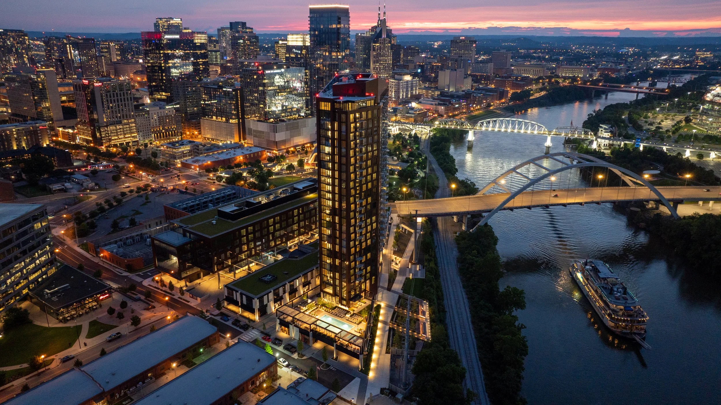
Nashville Drone Co South Bank Aerial Photo
Anyone who has watched a high rise climb out of the ground in Nashville knows the process moves fast. Steel and concrete stack floor by floor, and within months a skyline changes shape. What most developers do not realize until it is too late is that the same speed working in their favor on the construction schedule is working against them when it comes to capturing the views their future residents, tenants, and buyers will one day pay a premium for.
The honest answer to "when is the right time" is simple: earlier than you think, and before a crane goes up.
The Closing Window Nobody Talks About
Every high rise construction site has a brief period where the building's future sightlines are still fully accessible from the air. This window opens once the site is cleared and foundation work is underway, and it starts closing the moment the first tower crane is erected.
Cranes are a practical necessity on any vertical build, but they are also one of the biggest obstacles to clean aerial photography. A crane boom parked in front of a skyline view, a jib swinging through a shot, or a counterweight blocking the exact angle a future twelfth floor balcony will have; these are not problems a drone pilot can edit around later. Once the crane is in place, certain angles are simply gone for the duration of construction.
Floor height creates a second closing window. As soon as a floor is topped out and enclosed, the specific vantage point that floor would have offered is no longer accessible by drone. A drone cannot fly through a poured slab or a framed wall to capture what the view would have looked like from inside a unit that no longer has open air where the camera needs to be. That view existed for a matter of weeks during construction and then it was gone.
This is why timing is not a minor scheduling detail. It is the difference between having authentic, sellable imagery for every floor of a building and having none at all for the upper levels once the structure tops out.
The smartest developers treat drone photography as part of the construction schedule itself, not an afterthought that gets penciled in once the building is finished. That means checking in with the project's general contractor or site superintendent early, understanding the crane placement plan before it happens, and mapping out which floors need to be captured and on what timeline. A shoot planned around the framing schedule, floor by floor, can document sightlines that would otherwise be lost the moment steel or concrete closes them off. Waiting until the building is farther along almost always means losing access to the lower and middle floors, since those views close first while upper floors are still under construction.
What Happens After the Window Closes
Once the ideal aerial window has passed, developers are left with far more limited and far more expensive options.
Some developers turn to architectural renderings to fill the gap. Renderings have their place in a marketing package, particularly in the very early stages before a single beam goes up, but buyers and tenants have grown far more discerning. A rendering is understood to be an artist's interpretation. It shows what a view is supposed to look like under ideal conditions, not what it actually looks like on a hazy Tuesday afternoon or during a golden hour sunset over the Cumberland River. Real photography closes that credibility gap in a way no rendering ever will.
Is the Cost of Aerial Photography Worth It?
For a high rise development, this question almost always comes down to the value of the sale or lease being made. A single unit view can influence a buyer's decision on a six or seven figure purchase. A retail space view can determine whether a national tenant sees enough foot traffic and skyline exposure to sign a lease. The cost of a properly planned drone photography campaign is a small fraction of the value that a single strong sale or lease adds to a project's bottom line. Compare that against the alternative. Once a building is complete, capturing those same views again requires expensive still phoyography, coordination with the property, and in many cases limited access to floors that are already occupied. What would have taken a single flight during construction now requires a logistics plan, permissions, and a budget that dwarfs the original cost. There genuinely is one real opportunity to capture every floor's view efficiently, and it exists only during the build.
Why High Resolution Views Sell Space
Photography plays a different role at every stage of a project's sales and leasing cycle, but its impact on the closing decision is consistent. Buyers touring a condo before it is finished want to see, not imagine, what their morning coffee view will look like. Prospective retail tenants want to see their signage sightline from the street. Office leasing teams want to show a boardroom's skyline backdrop before the glass is even installed. High resolution aerial photography answers all of these questions with evidence instead of promises. A crisp, well composed image taken from the exact elevation and orientation of a specific unit does more to close a sale than pages of specifications ever could. These images end up on listing pages, in leasing brochures, in investor decks, and across social media campaigns that build anticipation months before a single unit is move in ready. A strong aerial photo library becomes one of the most reused assets in an entire marketing campaign, showing up again and again across channels long after the shoot itself is finished.
Giarratana Development has seen this play out firsthand with the future condos of their 60 story Paramount tower. One image in particular, captured by Nashville Drone Co from what will become the building's penthouse level, has taken on a life of its own inside the project's marketing efforts. The team has come to call it the Billion Dollar Photo, and it has since appeared across multiple ad campaigns tied to the building. It is the kind of shot that only exists because it was captured early, well before the floor it represents was fully enclosed. Giarratana also relies on the high resolution stills and 360 degree panoramic images taken during those early construction phases inside its sales presentation office, giving prospective condo buyers a way to stand in the room and see the actual view from any floor in the building, not a rendering of what that view is supposed to look like.
Sales teams often underestimate how long a single well timed photo shoot will keep paying off. A gallery captured during construction can carry a project from its earliest pre sale phase all the way through grand opening, then continue to serve as content for anniversary posts, press features, and case studies long after every unit is sold. Compare that to the cost of a single rendering package, which typically covers only a handful of predetermined angles and cannot be updated once the building's actual lighting, landscaping, and surrounding skyline are in place. Real photography adapts to whatever the marketing team needs next, whereas a rendering is locked the day it is delivered.
Nashville Drone Co's Approach to High Rise Timing
Nashville Drone Co has worked with high rise developers across Middle Tennessee who understand this timing challenge firsthand. The team plans shoots around construction milestones rather than waiting for a project to reach a convenient stopping point, coordinating directly with general contractors and development teams to capture each floor's unique vantage point before it becomes inaccessible. That kind of planning takes more than a drone and a clear sky. It requires an understanding of sun position and time of day for each specific compass direction a building faces, camera settings that hold detail in both the sky and the shaded building facade, and a precise method for calculating elevation so that a photo taken from what will become the twentieth floor is actually captured from the twentieth floor's true height above sea level, not an approximation. Nashville Drone Co built its process around exactly this kind of accuracy, treating every shoot as a technical exercise in matching a future floor plan to a real world elevation before that floor exists. This attention to detail has made Nashville Drone Co a familiar name to developers working on condo towers, mixed use projects, and commercial high rises throughout the region.
Beyond still photography, the team produces marketing video that walks viewers through a property's story, from the construction process itself to the finished views a resident or tenant will wake up to every day. These videos and photo galleries are frequently the centerpiece of a project's sales center presentation and digital marketing rollout.
Not Limited to Nashville
While the name reflects the company's home base, Nashville Drone Co regularly travels beyond Middle Tennessee for developers who need this same level of construction phase planning and accuracy in other markets. High rise timing challenges are not unique to any one city, and developers working in secondary and tertiary markets across the Southeast face the exact same closing windows once cranes go up and floors get enclosed. A development team with a project outside Nashville can bring the same construction schedule coordination, FAA certified flight operations, and elevation accuracy to their own market.
The Bottom Line
The right time to schedule drone photography for a high rise build is not after the ribbon cutting. It is during the earliest phases of construction, before cranes obstruct the skyline and before floors close off the exact vantage points future buyers and tenants will one day call home. Developers who plan for this window end up with a complete photo and video library that supports every stage of sales and leasing, from the first rendering shown to an investor to the final unit sold to a resident. Those who wait are left choosing between expensive workarounds and marketing materials that simply cannot compete with the real thing.
View Nashville Drone Co’s Gallery
Contact Nashville Drone Co to capture your future high rise views. info@nashvilledrone.co