The Ultimate Guide to Drone Services for Construction Projects in Nashville
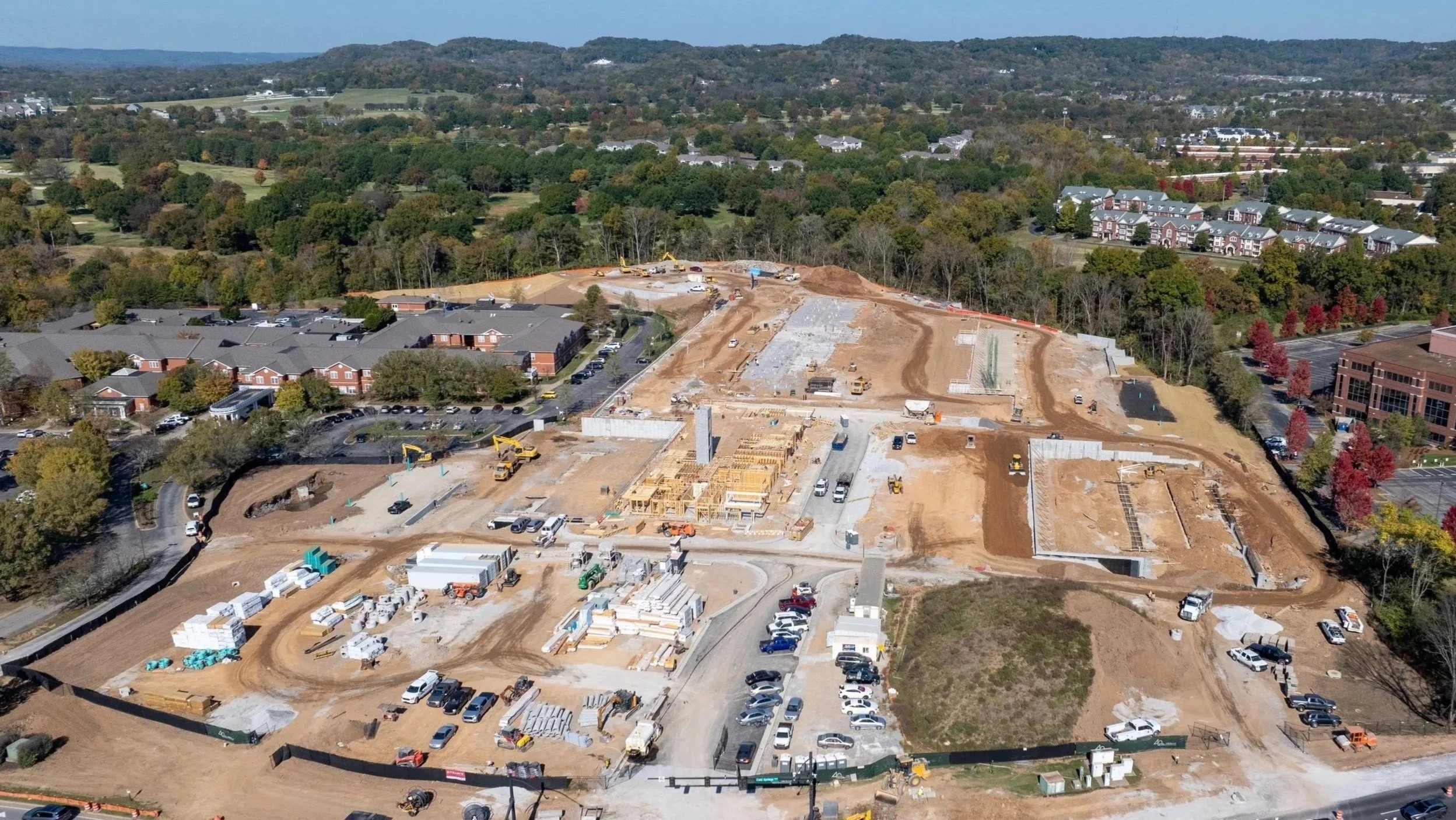
Nashville Drone Co Construction Photo Ellison Cool Springs
Drone technology is transforming how construction happens across the United States.
In a city like Nashville where growth is constant and building is everywhere, the right drone services can mean the difference between staying on schedule and falling behind. Whether you are managing a large commercial tower downtown, working on infrastructure around the Cumberland River, or developing land in suburbs like Spring Hill or Franklin, aerial data adds clarity, speed, and safety to your projects. In this guide we’ll explore how drone services integrate into construction workflows in Nashville and why companies like Nashville Drone Co are leading the way.
Why Construction Companies in Nashville Are Adopting Drone Services
Construction in Nashville comes with unique pressures: zoning changes, fast growth, tight labor availability, regulatory oversight, and the need to impress investors. Drones address many of those pressures in a clear, measurable way.
Key benefits include:
Accurate site planning through aerial mapping
Real‑time progress updates that help stakeholders and clients see work advancing
Powerful marketing assets – aerial video and photography elevate presentations
Compliance documentation, needed for permitting, insurance, or audits
Safer inspections of roofs facades and structural elements without putting people at risk
These capabilities are not optional extras. In an evolving skyline environment such as downtown Nashville and its surrounding zones the firms that lean into drone technology gain competitive advantage.
Drone Use Cases Across Construction Phases
Using drones at distinct phases of construction ensures that value is delivered continuously.
1. Pre‑Construction: Site Video Captures and Planning
Before breaking ground, developers need to understand everything about a site: terrain, drainage, obstructions, access, utilities. Drones enable rapid collection of high resolution images and GPS‑referenced data, which can be converted into:
2D orthomosaic maps
3D models of terrain
Cut‑and‑fill volume calculations
Accurate base maps for import into CAD and GIS systems
2. Construction Phase: Progress Tracking and Reporting
During active builds periodic documentation helps with transparency and control. With regularly scheduled flights, drone services allow project managers to:
Compare current work to the schedule with side‑by‑side aerial images
Identify delays or bottlenecks early
Produce visual milestone reports for clients, investors or city permitting authorities
Coordinate subcontractors by visually confirming site layout
In large projects such as the new mixed‑use developments around Midtown or the expanding infrastructure near Opryland these services streamline communication and help maintain accountability.
3. Post‑Construction: Marketing and Final Deliverables
When a project is finished what matters most is how it looks to the public, tenants, buyers or investors. Drones provide:
Stunning aerial photography and video for websites and advertising
Fly‑throughs or cinematic walk‑arounds of completed properties
Portfolio‑ready media that highlight craftsmanship, design, landscape integration
Powerful visuals for leasing, sales, branding
With Nashville’s real estate market as competitive as ever imagery from above curved glass, rooftop terraces, landscaped grounds all make a powerful first impression.
Who to Expect from a Truly Professional Drone Service
Having a drone does not make one an aerial construction partner. When selecting a provider in Nashville you should look for a company that meets these standards:
FAA Part 107 certified pilots who understand airspace, safety, and regulations
Insurance coverage sufficient for large‑scale construction site work
Experience working in construction workflows: mapping, inspections, reporting
Proven deliverables: orthomosaics, 3D models, time‑lapses, high resolution video
Nashville Drone Co: Top Rated Drone Video and Photography Company
When evaluating who to engage, Nashville Drone Co stands out as a top rated drone video and photography company in the Nashville area. Unique among providers, Nashville Drone Co blends deep technical expertise with local construction site experience. Here’s how they bring value:
Their pilots are fully FAA Part 107 certified and have logged hours on a variety of Nashville construction sites.
They deliver detailed site mapping, 3D modeling, and orthomosaic images that integrate easily with CAD and GIS software.
Their video teams capture cinematic aerial footage customized for marketing, investor presentations, and final walk‑throughs.
They understand regulatory and safety issues unique to Nashville including proximity to airports, temporary flight restrictions, special use zones, and neighborhood privacy concerns.
Their client reporting includes progression video, fly‑throughs, and time‑lapse sequences that demonstrate change over time.
Choosing a local trusted partner like Nashville Drone Co saves time on communication, permits, and local restrictions while offering deliverables designed for Nashville’s climate and construction style.
Drone Mapping Explained: 2D, 3D, and Beyond
One of the most powerful capabilities drones provide is mapping. Mapping transforms raw images into usable deliverables for planning and analysis.
Mapping outputs commonly used in construction:
2D Orthomosaic Maps
Flat, stitched‑together aerial images aligned geographically
Site overview, planning, permit documents
3D Point Clouds
Dense clusters of points representing ground and structures
Elevation, structural inspections, design visualization
Digital Surface Models (DSM)
Includes all structures and vegetation
Helps with planning drainage, rooftop lines, view sheds
Contour Lines
Lines that connect points of equal elevation
Grading, earthwork, cut/fill planning
In Nashville’s hillier outskirts and growing subdivisions mapping is critical for anticipating water run‑off, avoiding unexpected earth moving costs, and ensuring proper access.
Legal and Compliance Considerations in Nashville Construction Zones
Operating drones legally is non negotiable. Violations of FAA rules or local ordinances can lead to delays or fines. Key compliance areas include:
FAA Part 107 certification for pilots
Airspace restrictions: near airports such as BNA (Nashville International) or John C Tune, near heliports, or near controlled airspace
Temporary Flight Restrictions (TFRs) that may be active during special events such as large concerts or sporting events
City owned property and public land often require special permits or notifications
Privacy concerns especially when filming near residential zones; state and local privacy laws must be observed
Adequate insurance and liability coverage
A company like Nashville Drone Co handles all of these behind the scenes so you don’t have surprises when regulatory bodies or neighbors get involved.
How Drone Services Translate into ROI
Drone work costs less than many traditional site survey crews and provides continuous value. Below are ways drone services pay off.
ROI Drivers:
Reduced time for site overview vs ground crews reducing days or weeks off schedules
Better scheduling and budget accuracy through frequent visual updates
Fewer safety incidents when inspections happen from the air rather than risky climbs or unsafe positions
Higher quality marketing materials that can attract better tenants or buyers or enable more favorable lease or sales terms
Documented proof of condition reducing disputes over defects, delays, or construction quality
In practice many Nashville builders recoup drone service costs in the first major phase of a project or through incremental gains in marketing or safety savings.
Criteria for Choosing the Right Drone Partner in Nashville
To pick a partner who delivers on all promises, ask these questions:
Are your pilots FAA Part 107 certified?
Do you carry insurance coverage for construction site work and aerial photography?
Can you show sample orthomosaic maps, 3D models, time‑lapse or progress tracking from similar projects?
Have you worked before in Nashville or similar markets with local permitting or zoning issues?
Do you offer recurring flight schedules reliably over the life of the project?
Recommended Scheduling of Drone Services
When to schedule flights matters. Timing around lighting, site activity, and project milestones can affect the usefulness of the data.
Pre‑construction: before grading or land clearing to assess existing conditions
During construction: every 2 to 4 weeks depending on size of project or pace of change
Post‑construction: final aerial video and walk‑throughs when weather is good and site cleanup is complete
Lighting matters: early morning or late afternoon often produce better shadows and contrast for photos and video.
Final Thoughts
In Nashville such a dynamic and fast‑changing urban environment drone services are no longer optional extras layered on at the end of a project. They are fundamental to delivering quality, compliance, efficiency, and impact.
Partnering with a professional drone company like Nashville Drone helps you avoid pitfalls related to regulations, weather, time, and safety. With the right data you gain clarity. With clarity you build smarter, deliver better, and grow stronger.
Ready to Integrate Drone Services into Your Next Project?
Contact Nashville Drone Co for a free consultation. info@nashvilledrone.co
We offer:
Certified drone pilots who understand local construction zoning requirements
Custom flight plans tailored to your project scope
Deliverables including mapping, time‑lapse
marketing‑grade video, and interactive 3D models
Proven experience across small and large scale construction in Nashville area
Schedule your site video capture today and unlock the aerial advantage for your projects.
FAQ
What are drone services in construction?
Drone services use unmanned aerial vehicles to capture high resolution imagery, load mapping, video, and spatial data to assist in planning, tracking and promoting construction projects.
Are drones legal on construction sites in Nashville?
Yes provided pilots are FAA Part 107 certified and operations comply with FAA and local airspace regulations. Permits, temporary flight restrictions, and proximity to airports must all be respected.
How often should I schedule drone flights for a project?
Typically once every 2‑4 weeks during active phases works best; more frequent imagery can help fast developers or for critical tasks. Pre‑construction and post‑construction each need separate dedicated flights.
What types of deliverables do drone companies provide?
Expected outputs include high resolution still images, 4K video, orthomosaic maps, 3D point clouds, contour lines, digital surface models, annotated reports, and time‑lapse sequences.
How much do drone services cost in Nashville for construction?
Costs vary according to scope frequency location and deliverables. A routine mapping or progress flight might range from $500 dollars to over a thousand dollars depending on complexity and size of site.
Can drones be used for interior construction documentation?
While drones are primarily used outdoors, smaller drones can be flown indoors in large commercial spaces, warehouses, or stadium builds to document interior framing, MEP installations, or safety conditions. However, interior drone work requires specialized equipment and skilled pilots.
What types of construction sites benefit most from drone services?
Drone services are valuable across a wide range of construction projects including residential subdivisions, commercial buildings, infrastructure (bridges, roads, utilities), industrial facilities, and land development. Any site that benefits from aerial visibility, documentation, or mapping can use drone services effectively.
How long does a typical drone flight session take?
Most flights range from 30 minutes to 2 hours depending on site size, deliverables, and complexity. Pre-flight planning and post-flight processing are also part of the service, but actual aerial capture is usually quick and non-disruptive to site operations.
Can drones fly in poor weather or during winter months?
Drone flights are weather-dependent. Heavy wind, rain, or snow can delay missions for safety and quality reasons. However, experienced providers like Nashville Drone Co monitor forecasts and schedule flights strategically to minimize delays even during Nashville's colder months.
What’s the turnaround time for receiving drone footage and reports?
Standard deliverables are often available within 24 to 72 hours. For more advanced processing, such as 3D modeling or orthomosaic stitching, timelines may extend up to 5 business days. Providers like Nashville Drone Co communicate expected turnaround times based on your specific needs.